I once had a dream that I could get a grant to support a project that involved bringing several OEC and YECs together. Each would propose a test of their geological model. They would lay out their assumptions and predictions before collecting data and then both sides would collect data to test each model and then they would compare results and conclusions. The “bent” rocks in the Grand Canyon would have been an excellent chance to compare models with both sides proposing the tests they would perform and what they would expect to find.
Alas, it was just a dream.
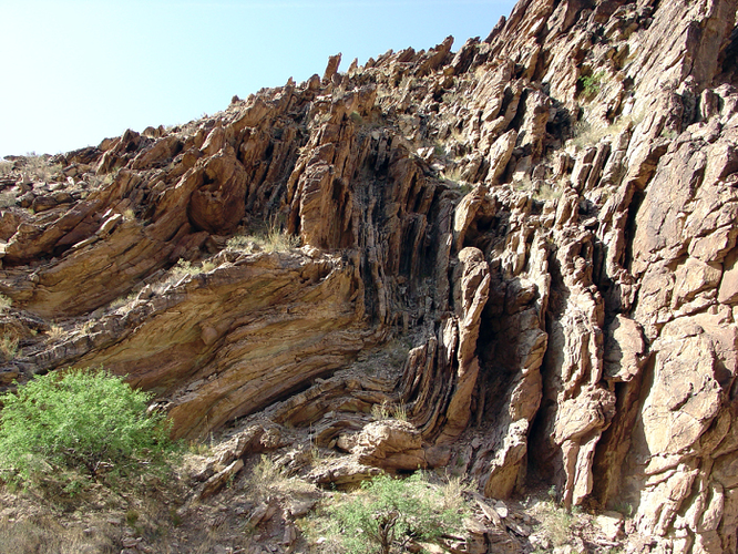
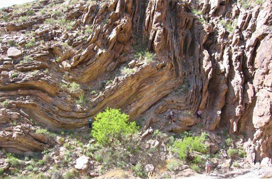
The YEC claim about the “bent” rocks in the Grand Canyon not being fractured is brazenly dishonest. Here is the AIG photo:
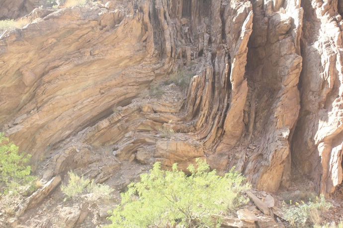
And here is a photo of the same rock formation taken by the US Geological Survey:
(Original photo is here: https://3dparks.wr.usgs.gov/grca/river/html2/grca2007.htm)
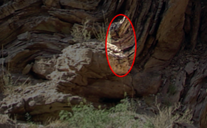
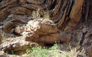
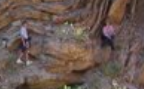
If you look at the corner of the fold on the USGS photo, you will see a couple of quite obvious fractures. These are obscured in the AIG photo not only by the fact that it’s out of focus, but also by someone strategically placed right in front of the most prominent one. Here’s a close up of the respective parts of the individual pictures:
@Joel_Duff
It’s been my observation that a lot of the scientific world is powered as much by money as knowledge. “If you have a good idea, the financiers (not to mention the grants) will beat a path to your door.” Oh that it were always so!
Like the oil industry, you mean? Their studies in the ages of the rock formations and oil deposits are motivated entirely by money, but their pursuit of money depends entirely on them being right rather than ideologically convenient.
@jammycakes
Since I’m not an expert on the issue…What are these fractures? What do they prove (or disprove)?
In the people in the AIG photo’s defense…If you have ever been to a national park (especially a more famous one) it can be extremely difficult to get a photo without people in it… 
Highlighted here:
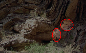
AIG claims that the “fact” that the rock layers bent without fracturing indicated that they must have been deformed before they had had a chance to dry out. This isn’t correct anyway, because rocks can plastically deform without breaking under heat and pressure over long periods of time. On the other hand, the fact that they were fractured indicates that they must have been deformed after they had solidified.
Here are a couple of more detailed discussions on the matter:
- Questioning Answers In Genesis: "Rock layers folded, not fractured" — or are they?
- Six bad arguments from Answers in Genesis (Part 6) – GeoChristian
- Evidences for a Young Earth | Letters to Creationists (search for “folded rocks”)
So how come the USGS managed it? The photo is one of a series of a hundred or so photos of the Grand Canyon, and only a tiny minority of them have people in them.
Also, why is one of the people concerned exactly in front of one of the fractures that AIG so adamantly claims do not exist?
USGS probably has authority to make humans obstructing the photos move, and they would have the ability to go to those areas at times when few other people do (Some of their other photos may be in areas that are not reached by actual hiking trails). That digression aside…What would the rock look like if it was not cracked there?
Anyhow, that rock aside, what do you say about the other “bent rocks” around the area that do not appear to be cracked?
Still doesn’t answer my question: why is one of the people concerned directly in front of the fracture?
In case anyone is interested, the landing page for the full picture gallery is here. Thumbnails for the individual pictures are here.
There would be no black line.
If you look closely, you will see that the other “bent rocks” around the area do have fractures in them. Some of these become clearer if you zoom in on the photograph. For example, there’s another one here (I’ve enlarged the picture to make it easier to see):
Fractures occur on all scales, right down to those that are only visible under a microscope, so absence of evidence is not necessarily evidence of absence. Especially in a badly taken photograph.
Where is the evidence that solid rocks would have to crack as they are being deformed?
The USGS photograph is captioned (follow the link in James’ post) Mile 64.5: Folded Precambrian (Proterozoic) sedimentary strata about 1.5 miles upstream along Carbon Canyon.
In other words, this rock formation is on the canyon floor, 1.5 miles up Carbon Canyon from the Colorado River. If you know anything about the Grand Canyon, you know that this is not the same as Mather Point in Grand Canyon Village on the South Rim at sunset, where a thousand people may be sitting, standing, rollerskating, or walking about on a summer evening. This is a wilderness location 1.5 miles up a side canyon in the heart of nowhere, accessed only by occasional backcountry hikers, who decide to make the trek while passing by on a rafting trip and perhaps camping on the beach where Carbon Canyon meets the river.
It’s obvious to me that the people in the photograph were almost certainly all of the same party and thus able to collude to hide a fracture or two if they wanted to. Whether that was their intention or not, we can only speculate.
Jonathan - none of your racionalizations stand up. Can you admit it?
My theory is that they added people to the image to give an idea of the scale of this geological formation.
That leaves open the question of why they are sitting/standing near the cracks. Maybe it’s easier to sit/stand there, or maybe it was orchestrated. We cannot know and it is not good to assume bad intentions on their part.
That’s quite possible, but the fact remains that they are denying that the cracks exist when it is abundantly clear that they do. It’s still lying even if their placement was merely a coincidence and there was’t any collusion. Also, why is the photo so poorly focused?
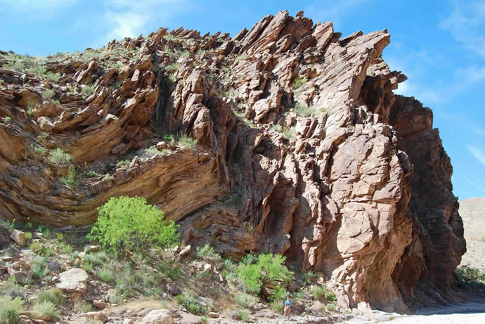
I actually found some more, better quality photos of the same formation on a blog post by Ken Ham here. You can see that the cracks are clearly visible in that photo as well:
One of the photos shows the rock formation from a different angle. It looks like you have to scramble up a bit past some scrub to get to the places where the people are in the photo. There’s nothing particularly easy or natural about those locations, though having said that they’re not unduly difficult either.
As far as I can tell, the location appears on Google Maps here.
For what it’s worth, I’ve blogged my findings here, in a post that’s part of an ongoing series examining AIG’s ten best evidences for a young earth:
Thanks for looking into this, James -and providing a link to where you discuss it more. You highlight YEC deception in their manner of photography, and I can’t speak for or against their intent or integrity in that. What interests me a lot more is the actual scientific discussion that informs the formations as seen in the best photographs you provide. It seems to me that there is a general display of plasticity even with the existing fractures that are there. The general visual impression of the phenomena is that much bending occured in addition to any/all fractures that also happen to be present. Am I mistaken to think so?
If that is accurate [that there is bending there], then does that mean that either: A> all the layers were still wet when they deformed? or B> they were already solid and dried out, but still exhibit a plasticity given enough pressure and time? I apologize if this was already hashed out somewhere above --but are the successive (ostensibly bent) layers in question individually dated and known to represent geologically large spans of time between sedimentation? --which would seem to eliminate option A. What does science actually say about these layers?
Does this talk origins response to “folded rocks”, short as it is, apply to the case shown in your photos above? I guess the only question I have is whether the layers in question are actually thought to span millions of years – I presume they would be or YECs would have nothing to gain by contesting their status.
That’s a very good point Mervin.
The critiques I linked to above (Questioning Answers in Genesis, The GeoChristian, Letters to Creationists) provide some quite detailed discussion here. In short: rocks can and do deform plastically under higher temperatures and pressures over long periods of time, so if the rock formations had been buried deep underground in the past, they could quite easily have deformed in this manner. The exact pressure, temperature and time that would be required will depend on the kind of rock. There have been experiments conducted on these rocks since the 1960s.
This particular layer is described by Answers in Genesis as being Tapeats sandstone. I assume this is correct. The Tapeats Sandstone layer is a long way down (it’s Cambrian/Precambrian or thereabouts), and it’s quite conceivable that this layer could at one time have been buried up to 2 km underground or more.
There’s actually another problem with the “wet deformation” hypothesis: namely, scale. When solid rock layers deform, they retain their integrity as separate layers. On the other hand, wet deformation would result in the different layers getting squished together into one more or less homogeneous mass. From this article here:
The Flood geologists attribute such folding to soft muds and sands produced by the deluge. Physically this is impossible. M. King Hubbert, Director of Geophysical Research for the Shell Oil Company contributed an excellent theoretical investigation on the matter of scale models. He showed-that in order for any laboratory attempt to reproduce earth conditions, it must keep all the dimensions of the model to scale. By using the known viscosities of solid rock at the temperatures and pressures of 5 to 10 miles in the earth’s crust, it can be shown that the comparable scale model material for a laboratory compression experiment would have to be modeling clay or shoemakers wax. Experiments with these materials under controlled conditions have produced Appalachian type folding, and in general the type of deformation observed in rocks. If the sedimentary rocks were once unconsolidated debris at the same time and the entire muddy mass was subjected to compression stress the result would be a chaotic mixture of material. The laboratory model to scale would be observed by squeezing a rubber flask which contained a layered mixture of alcohol and water. It would simply mix and spill out as a more or less homogeneous mass. Nothing of the type of thing observed in folded rocks could be obtained.
Then there’s the question of gravity. Maybe I’m missing something here, but I can’t see how vertical layers of rock thirty metre tall or more could remain vertical when they’re made of soft clay.
Another relevant article (this post on Internet Monk) quotes the book Grand Canyon, Monument to an Ancient Earth as saying this:
Faults in rock look very different from those in soft sediment. In rock, a relatively clean break occurs that is often filled with angular fragments of broken rock (called breccia), or with pulverized rock as one side of the fault grinds past the other. Where bending of the rock occurs, cracks are readily visible in the deformed rock. In soft sediments, however, there is no clean break and sediments are spread out along the blurred rupture zone. Because the material is soft, there is little or no breccia, nor do we find pulverized material lining the sides. Faults in the Grand Canyon are characterized by sharp breaks filled with rock fragments, and bent layers adjacent to faults are fractured. Faults in soft sediment don’t look like this.
This article here includes a marked-up version of the photograph showing where some of the more obvious fractures are:
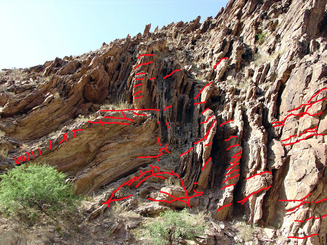
Hey Mervin! I liked your reply. It reflects my seeking. I looked up this fold as part of some research and have yet to find a good for/against scientific study. From what I’ve seen, it’s physically possible for the layers to bend (like we see) under softer conditions (but not soup/underwater mud). I think it would have to be the right level of soft, but the concept is easy to grasp and believe. Honestly, I just find it hard to believe rock could physically bend like this without heating up a LOT and metamorphosing into schist or some other metamorphic type rock. I’m not a geologist and don’t consider myself a creationist, but that’s just my own logic kicking in from what I’ve read. Also, hasn’t anyone else considered that those cracks may have occurred at any point in history, this being rock in a turbulent environment?
I’m honestly trying to find a good explanation, and so far neither side has excluded the other, although at this point it’s easier to believe the rock was soft. Not muddy, but layers of semi-dry sand/dirt would easily retain their shape/layer and bend just like this under the right conditions.
Maybe it’s just too big/old for my brain to comprehend.
Hi Mercy,
It’s good to see you’re thinking this one through. You’re asking some good questions here.
The “right level of soft” will be dependent on the size of the formation: it will be much harder at larger scales.
You can easily see something similar in your kitchen if you try to make figurines out of dough. You can easily shape the dough into dinosaur shapes, for example, if they’re just two or three inches high. On the other hand, if you try to scale them up to a kilogram or more, you’ll start to have difficulty keeping everything in place without it all slumping down into a shapeless mass on your kitchen counter.
Soft sediment deformation does happen, but the scale of the deformation is generally quite small, and it has a characteristic appearance. Here’s a blog post showing what it actually looks like in practice. You’ll see there are all sorts of deformations, but they are only a fraction of a metre across. The particular rock formation we’ve been discussing in this thread is about 30 metres tall.
The key to this one is to look for measurements. There’s been a lot of research into what temperatures, pressures and timescales are required for different types of deformation and metamorphism.
Here’s another useful article: it shows what kind of temperatures and pressures you need for metamorphism to occur. It’s quite possible that you could see ductile deformation over a long period of time at temperatures and pressures towards the edge of the “sedimentary” zone, or that there could only be a small amount of low-grade metamorphism. It depends on the type of rock. (This particular rock formation is sandstone.)
They would have to have occurred after the rock had solidified. If the rock had still been soft, the cracks would have merged together again.
You might find deformed fossils to be of interest. These are fossils made out of rock (i.e. permineralized), and you can find them in geologic layers that have been bent by tectonic forces. What you find is that these fossils have deformed with the rock. Here is a scientific paper on tectonically deformed fossils if you are interested.
Also, Silly Putty is a decent analogue for how rocks can deform. When you bend Silly Putty slowly it will deform without breaking. If you bend it quickly it will fracture. Rocks can have the same type of plasticity.
