I just came across an older discussion regarding flat earth theories. I dont want to say I believe the earth is flat. I do however have some questions on the topic. First and foremost, if the flat earth theory is basically coming from silly or uneducated sources, then can someone tell me why the flat earth map is the map used on the United Nations flag? That should be enough for some people to look more seriously into it. The globe makes perfect sense. Don’t get me wrong. We can’t however just dismiss the flat earth theory until there is just as much evidence and information for us to make an educated opinion.
I agree that many people dismiss the flat earth theory far too easily, using Horus Atheist style arguments like “Where is the edge?” and “Why are other planets round?”.
That being said, the Flat Earth theory is ridiculous for the simple notion that it assumes the phenomenological cosmology of the ancients is somehow more accurate than our modern day scientific cosmology
2 Likes
My favourite FE theory is Mark Sargent’s theory that the entire sky is a hologram.
Welcome!
I agree that brilliant people can miss the forest for the trees. But back thousands of years ago, the Greeks knew that the earth was round (and estimated its measurements) based in part on the horizon effect of a ship, and the shape of the moon cast by the sun, with other measurements (there was triangulation in there somewhere too–someone smarter than I can put that in, or I can wait till I get home and look it up in the children’s book I read a few weeks ago. I am in a way just like the flat earthers–I had no idea it was so easy to prove, till I read it :)).
Thanks for the discourse, and welcome again!
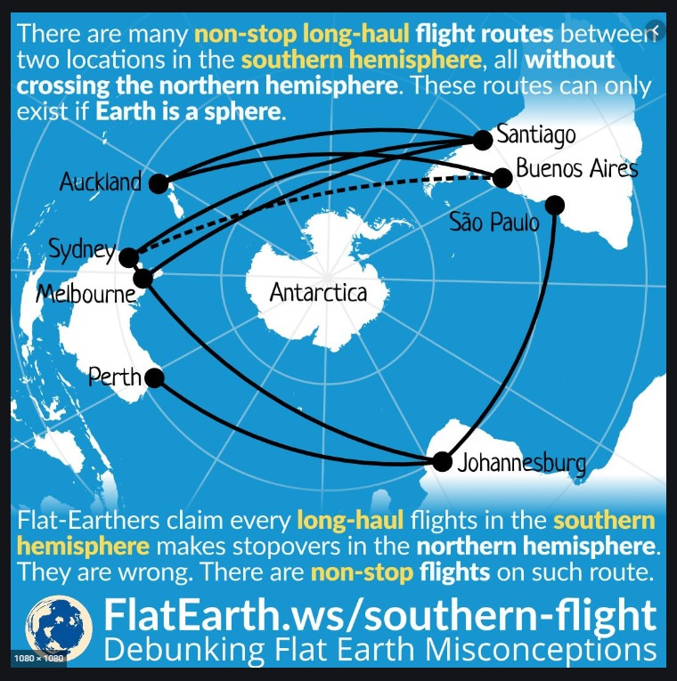
If you don’t believe in NASA photography, the quickest way to prove the Flat Earth view is wrong is to look at flight times and fuel consumption for trips to/from the tip of South America, Australia, and destinations in China.
Either the world is a sphere, where South America and Australia are relatively close to each other…
Or it is flat, and it is impossible for southerly South Americans to reach Australia with no stops…
Not to dwell on the totally different views from the plane’s window for flat earth plane travel!
7 Likes
Compare the two images - - one showing how impossible flights in the Southern Hemisphere would be if the Earth was Flat…
vs. the other image which shows actual flights that are made between South America, Africa and Australia - - all without crossing the Equator once!
[Click image to maximize legibility!]

.
.
[Click image to maximize legibility!]
4 Likes
The polar projection was used as it shows all of the continents, with the exception of Antiartica, at one time. In other words, it shows all of the nations as indicated by the title of the organization.
Easy peasy.
Now if you want to dive into conspiracy theory, which the FE folks have to embrace, then it was chosen as an indication that the truth is the world is flat.
5 Likes
My personal theory is that UN’s “flat earth” logo was designed intentionally as a test; those who interpreted the logo to think the world was flat would be marched to the edge of the Earth, and given a little nudge!
1 Like
Your “Flat earth map” unfortunately is not the correct map. Again refer to the United nations flag. That changes everything in your explanation. And as far as flight paths go… look deeper into all the "emergency landings planes have .ade for medical or mechanical reasons, that make no sense what so ever , unless they were flying over what we call the flat earth representation. Again… just things to make people think
Well that makes much more sense then any other reason that could be possible. Haha I do enjoy your tongue in cheek response for the mere fact it probably made people giggle. (The little nudge)
Round seals are popular, so they wanted one of those. They also wanted all of the UN nations to be on the seal. The polar projection of the globe fits all of those criteria.
We can see stuff going below the horizon, such as ships, the Sun, and the Moon. That should be enough right there. If Flat Earth is true then the Sun should stay above the horizon and change size as it moves away and towards us. That doesn’t happen. Instead, the Sun and Moon stay the same size throughout their movement through the sky. Pictures from space are also quite convincing.
4 Likes
On the Flat Earth map, the distance from South America to Australia is twice the distance as NY to Tokyo. On a globe Earth, those distances are about the same. According to flight times, it takes the same amount of time for both flights. Globe Earth wins.
Also, this picture:

4 Likes
Scientific explanations! Thank you. This is what I’m looking for. Not to dismiss your reply (because I seriously am looking for real explanations and opinions) but there have been many tests on the horizon theories. I was shocked watching a video on a lake using a boat and a lazer that showed the fact we lose sight is distance and not from curvatures.
See picture above.
Yet on a flight from Hawaii to California an emergency stop was made in Alaska? How does this make sense?
I didnt produce a UN flag because it doesnt matter.
I would love to see the UN image you think changes my “flight plan” analysis one bit.
I’m not trying to change anyone’s opinion. I’m looking far answers. I’m look for explanations that are indisputable. That’s all I’m trying find
The only references I can find are for a flight from Asia to LA. This makes sense since they often take a polar flight because it is shorter on a globe.
2 Likes
Yes. I’ve heard of that explanation. And it does make some sense. It also makes sense on a flat earth where the flight path is direct and not a detour. Again trying to find indisputable explanations. Thank you.
What doesn’t make sense is flights in the Southern Hemisphere on a flat Earth. Those only make sense on a Globe Earth.