I’m currently in an aviation ground school program and was going through some the weather section of it and, for whatever reason, it doesn’t seem to be clicking for me.
For the most part, I understand most of the concepts present, but sometimes I seem to struggle to understand the nature of why things happen, and suppose that trying to understand that is what will help me know it better than just trying to memorize it.
A few questions come to mind.
Why exactly does uneven heating of the Earth’s surface occur at a local level if the area is more or less receiving the same amount of sunlight (thus causing thermals)?
Why is a warm front able to move onto a cold front if the direction of air flow is meant to be from high density (cold) to low density (warm)?
How do stationary and occulted fronts work? Also, why does the weather we see at each type of front (cumulonimbus and thunderstorms when a cold front approaches a warm front; stratus clouds when a warm front approaches a cold front, etc) actually occur in that order?
Similar to the thermals question, why do areas of high and low pressure exist?
Why are there three separate bands of coriolis force in both the North and South hemisphere?
How do temperature inversions (where temperature goes up with altitude instead of going down) occur?
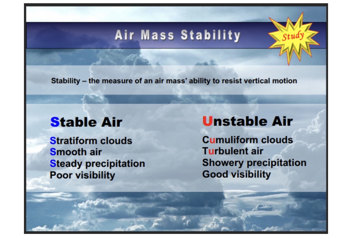
What causes air to become stable (to resist air movement)?
Also related to the thermals question: Why do large bodies of air develop with similar characteristics throughout even though thermals exist?
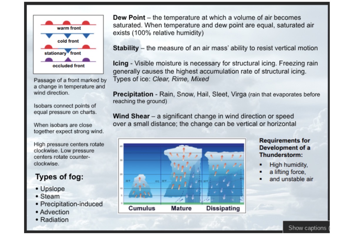
These are some of the bigger questions I have now. Here are some of the notes I have from the course if you need reference to what I’m referring to:
Let’s ignore for the moment the fact that not every given square meter gets the same amount of sunlight … some of those square meters (at extreme latitudes) are at quite an oblique angle to the sun, and other square meters (in more equatorial latitudes) get much more direct sunlight (meaning actually more of it!). Some are under cloud covers; others not. Some may be in the shadow or contour of a mountain and others not. But all that messiness aside - let’s grant your premise: every square meter gets the same radiative energy from the sun.
Even with that unrealistic premise granted, there will still be uneven heating. Because not all square meters are able to absorb the same amounts of that given quantity. Some are highly reflective (like snowy surfaces), which means they just reflect more radiation back up into the atmosphere or even space. So even if every square meter got exactly the same radiation applied to it, still - some areas (the less reflective ones) would warm more than others (more reflective). Pavement absorbs and radiates differently than pasture or forest. Which contributes towards some metro-areas being relative “heat islands” with rising thermals that birds can take advantage of.
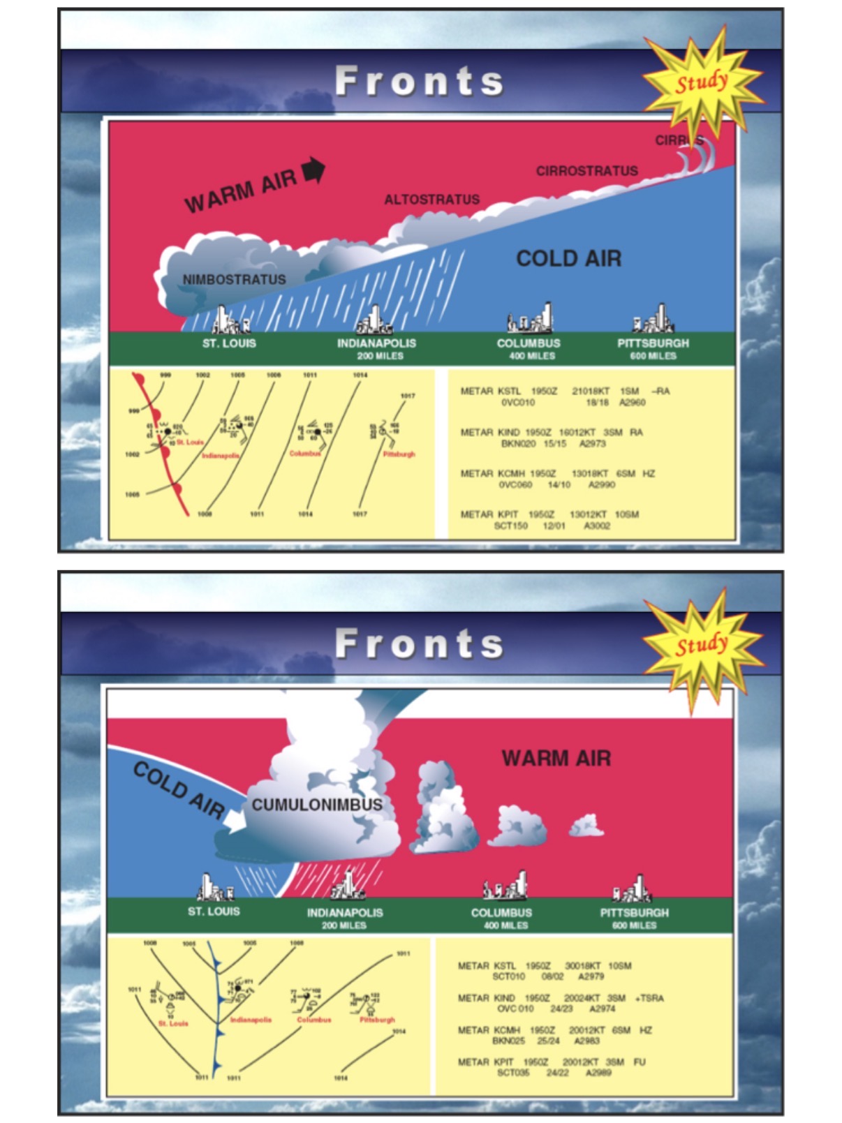
I think you may be confusing a couple things here. Direction of air flow (wind) is determined by relative pressure centers. Air does move from a high pressure area towards a low pressure area. But don’t confuse pressure with density (or temperature). Those are all three interdependent (but distinct) properties of a gas. Just because you might see a “high pressure” point on a weather map, doesn’t necessarily mean the air there must be “more dense”. Temperature plays into that too and helps determine volume (and thus density) (remember the combined gas law from chemistry class). In fact in the very diagrams you helpfully included - look at the top two. The very top one has a warm front (an entire warmer air mass) doing the moving. And because it is less dense than the colder dryer air mass it is encountering, the warm one gets lifted (like going up a ramp) - which then elevates and depressurizes, and thus cools the warm air mass so that precipitation occurs. In the next pic down, it is the cold air mass doing the moving. But being the denser one, it still stays underneath the warmer air mass it is encroaching upon. Think of that being like you shoving a wedge underneath something. Your wedge lifts it up. The same effects occur - potential rain! The actual movements of these masses are being determined by other things (nearby pressure centers) not being shown in these simple diagrams.
Those my answers to your first two points anyway. Will see how this goes or if others chip in as well.
Oh yeah I knew this already (which is why summer and winter are switched for each hemisphere due to the fact that Earth has a tilt, so in Northern summer the south hemisphere is tilted way down).
This is what I needed help with ! I probably should have been more specific but, regardless, thank you so much for the help!
Uneven heating will do that. If area ‘A’ is hotter (absorbing more sunlight) than adjacent area ‘B’, then (all else being equal), it causes the air mass at ‘A’ to expand a bit - making it less dense. Then the heavier air at ‘B’ wants to “spread out” and occupy more space underneath ‘A’ which then gets pushed up. You could actually observe this flow (convection) if you applied localized flame heat to the bottom of just one bit of a large pan full of some water. (sprinkle a few things into the water to help you see its currents). The water directly above the heat source rises and is replaced by cooler water rushing in from the sides. Or … forget the water. Build a fire! then you can directly see the warmer gases (smoke) rising, which means that air is rushing in at the sides to replace it (which also conveniently - or not!) gives fresh oxygen to the fire! The “fire” represents a “low pressure” center on a weather map. Because in the 2-D surface world of the map, lateral air flow along the ground (what we experience as wind) is moving toward the low pressure center (in this case the ‘fire’). And that colder, heavier air pushes the warm air out of the way, and it goes the only direction left for it to go: up! Because heavier things like to stay down, pushing the less heavy things up out of their way.
That helps a lot, but how that also makes me wonder why large areas of the map then experience uneven heating like so to create the specific high and low heating areas. I understand how it works on a local level (clouds, large shadows, different surfaces) but what about on the large scale?
Or as my son, a PhD in Meteorology, says, “Imagine a black top basketball court surrounded by green grass. The court will absorb more heat and therefore heat the air above it more than the air above the grass. After that it is just thermodynamics.”
If you really want to understand the mechanics behind weather I would suggest you find a used copy of a Meteorology 101 text, one of which I have somewhere around here, and read up. Quite interesting to me.
Correction: Replace “you” in the above with @BuffaloMax17.
The effect over a large area is just the sum of what happens on a smaller scale. Think integration over the entire area. Two different areas may have different summations and therefore different final temperatures. This gives you high and low pressures which then get acted on by the Coriolis effect which generates the rotation around the high/low pressure areas. See isn’t weather fun?
And then there is the Global Atmospheric Circulation, i.e. Jet Stream, which moves the areas around.
The answer is “albedo”, which is a measure of the amount of light reflected, along with re-radiation, the amount of non-reflected insolation that gets re-radiated as heat.
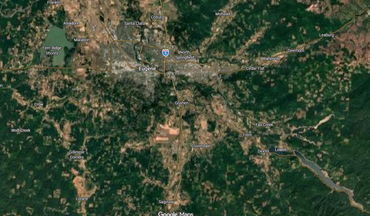
In this image of an area of Oregon there is forest, farmland, cities/towns/, highways, lakes, and rivers, all of which have different albedos and different re-radiation factors. For example, dense forest and highways have similar albedos yet highways re-radiate intensely.
As a result of the differences, an equal amount of sunlight hitting forest as highway or city has different results: the forest remains cool, the highway and city becomes hot. Air rises above the hot areas and sinks above cooler areas, and the result is called “turbulence”.
Those are quite local, but over larger areas there are also differences, and the turbulence moves air. Add in the differences in humidity, and the fact that hot air and cool air have different densities, and voila! – weather.
Momentum. Air masses moves coherently until they encounter something different, where you get – again – turbulence.
And so on. There are probably sources online that do a far better job of explaining it, but weather boils down to physics, primarily of gases and heat transfer.
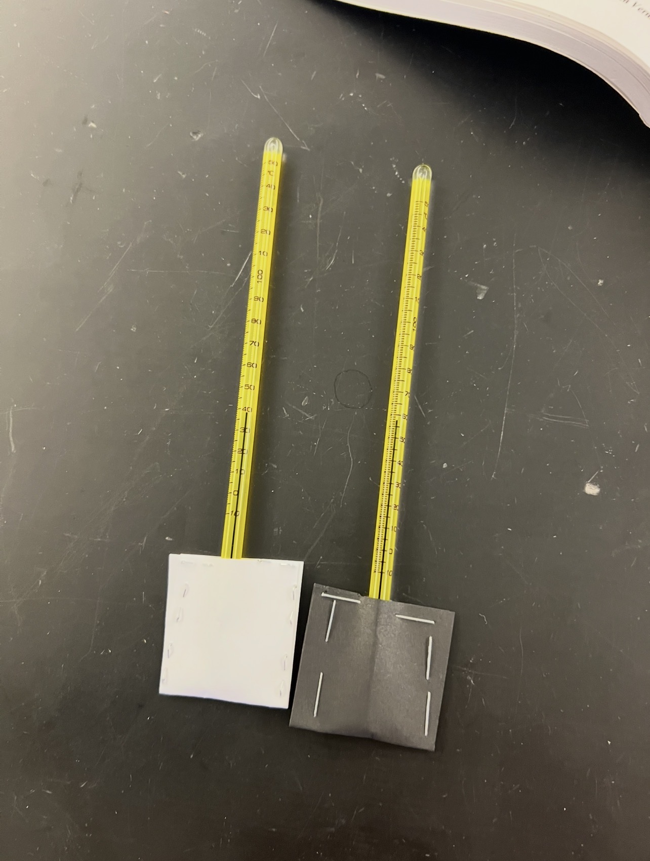
Different materials reflect and absorb heat differently. Compare sand and water, asphalt and grass, or a road with snow and one without.
Large air masses generally retain their characteristics. A cold front is the leading edge of cold, dense air, when that slams into warmer air it will naturally create lift.
Unequal heating. For a zoomed out view look at Hadley cells and global circulation. Climate is driven largely by latitude and the angle of incoming solar radiation.
The wind aloft travels very fast but moves parallel to isobars due to Coriolis force. Hence we get upper level rivers of air like the jet stream.
There is a host of reasons for an inversion. It’s just a layer of warm air above colder air.
Air that rises adiabatically cools (expands due to less pressure). It warms in areas of subsidence (downward moving air as in high pressure systems). They can also be formed by fronts (cold hitting warm), advection (when warm air moves over a cold surface) or even radiative cooling.
Inversions are important for thunderstorms as they act as a cap suppressing instability. You may have heard of CAPE in your studies (convective available potential energy).
If you are studying these questions are all pretty generic. I suspect an AI program will do very well in answering them. But the resource I used most is the goat Jeff Haby. His page is S-tier.
I have some fancier sets ups and equipment for demonstrations but for a quick 15-20 minute mini-experiment that can put students in really small groups, this gets the job done.
 ! I probably should have been more specific but, regardless, thank you so much for the help!