Because it takes time to form layers of sediment of that depth, whereas a tsunami would leave jumbled layer of mixed material, most of which is the pure existing material that was there before. Then. In you have a layer of volcanic rock, it has to flow over that, cool and harden. Then repeat, And actually to have biblical literalism, the water rise took place ov 40 days, so that compresses things even more.Or 150 days according to some renderings.
But, whatever floats your boat. For me, just too many inconsistencies to accept a literal interpretation.
First: your contention that North America was completely underwater is dubious. For example, here is a USGS map of America during the Absaroka megasequence:
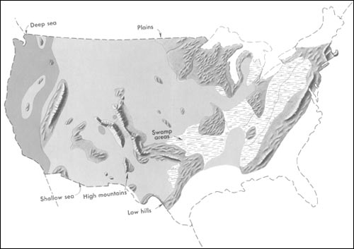
Looks to be about 60% underwater. During warm eras when glaciers melted, perhaps only mountains remained above sea level. But that’s 95% submerged, not 100%.
And from the same USGS website:
Examinations of older and older rocks show that in the earlier periods, the land areas of the North American Continent were much smaller and were largely confined to central and northern Canada.
Based on my examination of the USGS website, you have misinterpreted the Sloss diagram. If you could find a citation from USGS or a geology textbook that clearly states that 100% of the entire North American continent was submerged, kindly provide it.
Second: You yourself believe that North American non-marine fauna were completely wiped out 6000 years ago, then they were repopulated by a mass migration radiating from Mount Ararat in the course of a few hundred years. Am I right?
Then why would it not be possible for land animals to migrate to North America over a period of millions of years and repopulate it?
Third: There are serious physics involved in tectonics, as Clarey would no doubt concede. Can you point to where Clarey worked out the differentials for the friction and thrust involved with the hypothesized uplift of the Himalayas after the flood, for example?
Thanks,
Chris
1 Like
And that is NOT what I am talking about. Read my words slowly and carefully. There are no deposits of “massive amounts of ocean sediment” on the CURRENT sea floor. How does a global flood explain THIS?
1 Like
Well, for starters, the continental shelf is composed entirely of sediments, and eroded by massive underwater canyons that sometimes dwarf the largest continental canyons.
Ok perhaps I was unclear. The deep sea floor, not the continental shelf which is only a tiny portion of the sea floor, does not contain these massive amounts of flood sediments.
3 Likes
You are starting with the assumption that the surface of the earth before the flood was much like it is today. But it was much flatter, and there is plenty of water on the earth today to cover the entire earth when the topography was much lower. There is enough water now to cover 70 percent of the earth even now.
The continents lifted and oceans lowered during the later stages of the flood, along with rapid vertical tectonics and volcanism.
So show me some scientific data from geologists who published to a commonly read science journal verifying the heights and how they know it.
And for the record, my answer worked with both the current levels of elevation, and with sizes decreased all the way down to 1/2 a mile.
So it seems you avoided actual answers that highlight areas of contention with a unscientific speculation.
Here is one of the Sloss sequence diagrams:
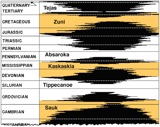
And here is their explanation of it:
Sedimentary “Sloss” Sequences of North America. In the Mid-Atlantic region, the Sauk, Tippecanoe, and Kaskaskia are well exposed. White and yellow areas represent major marine transgressions onto the craton while black areas represent major unconformities (sequence boundaries). The Sauk is bounded on the bottom by the “Great Unconformity”, the boundary between the Sauk and Tippecanoe is referred to as the “Knox Unconformity”, and the boundary between the Tippecanoe and Kaskaskia is the “Wallbridge Unconformity”. All six of Sloss’ Sequences are 2nd order supercycles. (Sloss, 1964)
And here is the website: https://opengeology.org/historicalgeology/case-studies/basic-sequence-stratigraphy-101-appalachian-cratonic-sequences/
So, according to their explanation, the “white and yellow areas represent major marine transgressions onto the craton” (i.e., continent–more specifically, North America…Laurentia, at the time).
So, this diagram–based upon actual borehole samples through the sediment layers, along with seismic testing, portrays periods during the Tippecanoe, Absaroka, and Zuni when the craton was covered by “marine transgressions”–that is, incursions of ocean (marine) water.
In fact, on diagrams (such as on the link I originally sent out), the time period for these incursions upon the earth can be estimated at 18 million years each, for the Tippecanoe and the Zuni; and estimated at 36 million years for the Absaroka.
And, to clarify, this is neither mere rainfall nor groundwater amounts, as you have misunderstood them to be–but catastrophic ocean “transgressions” and “regressions” over the continent.
Also, beyond Sloss’ work, hundreds of other borehole samples have been taken from South America, Africa, and even Europe. And though the megasequences are not called "Sauk, Tippecanoe, Kaskakia, Absaroka, Zuni, and Tejas (names that Sloss gave to the North American megasequences) the very same megasequences are found on all these other continents–again, testifying to a worldwide Flood.
This website gives further details:
"Pre-Flood geography" by Timothy L. Clarey and Davis J. Werner
Dennis Prager has a maxim that I find helpful in this kind of discussion–“I prefer clarity over agreement.” In discussions about the Genesis Flood versus uniformitarian models of geological formation, we may never agree. Rather, we should seek to understand both models accurately, not a caricature of either.
To gain this understanding, we must listen to and read both sides, to the extent that our limited time and life priorities allow this. And it is counterproductive to argue against a weak position or one that has been abandoned or doesn’t exist.
Here is an exceedingly brief summary of a well thought out Genesis Flood model:
In Michael Oard’s (and others) model of the receding phase of the flood begins with sheet flows off the continents, not tsunamis, and with channelized flow later. During the early stage of the flood, the flood waters moved by the coriolis effect.
Here are a couple of books that summarize a lifetime of careful research by Michael Oard and others:
Flood by Design, and How Noah’s Flood Shaped Our Earth. If you want to understand a good model of flood geology, read these books.
Not necessarily true. Of course, as demonstrated during the Mt. St. Helens eruption, hundreds of feet of sediment was laid down in layers in about a week’s time. I understand you are not disputing this.
But as to your “require still water and long periods of time statement”–What you have stated is axiomatic for uniformitarian geologists, but unlikely to be true. Read The origin of laminae in shales by Michael J. Oard at creation.com. And then go from there to other articles you find there that cite peer reviewed research from both creationists and from “standard” journals such as Science.
The issue of still water and long periods of time is not close to settled, is certainly in question and would be a fruitful area for further research.
Im not seeing anything by Laurence L. Sloss on believing his research showed a biblical flood. I’m not seeing any research to show that a event happened where water from the ocean tidal waved over all of USA and took a year to recede.
I don’t think anyone here is confusing sea water , ground water and rainwater. Especially not me. What I did was line out what was not possible, even if the earth had a max elevation of 1/2 in USA.
I also pointed out a major problem.
You’re saying a biblical flood can account for this false total USA submergence. But that would be silly even from a biblical perspective because it does nothing to account for Gondwana that existed at various times and was around during the time you mentioned. The biblical story takes place around the Middle East/ northern Arica regions. It does not take place here in USA not even with continental drift snd millions of years.
Once again, these are objective conclusions of geological research and not axioms. Geologists follow the evidence to where it leads.
3 Likes
Let’s start here: I think uniformitarian geologists believe that the entire earth was covered by water in its earliest stages. So there is enough water to cover the entire surface of the earth under some conditions.
Next, there are marine fossils on the top of many mountains around the world, including the Himalayan and Rocky Mountains. So at one time, these areas were under the oceans after there was life.
So the disagreement is not that the whole world can be covered by water, or that the areas of these mountains were once under the ocean, but when they uplifted, whether millions or thousands of years ago.
As to “commonly read scientific journals,” you are now bringing up the issue of who gets to say what counts for knowledge. Your contention is that we must follow consensus science. This position is fraught with serious philosophical issues, such as the dilemma of the dissenter. If we must follow the consensus, then there can be no dissent and the consensus can never be changed. Even uniformitarian geologists agree at times on changing their consensus.
So it is illegitimate to to ask flood geologists to adhere to your consensus by only accepting research published in uniformitarian geology consensus journals. It is unwise for uniformitarian geologists to ignore the research of dissenters such as flood geologists. And you might learn something from their research, even if you still disagree with their conclusions.
Chris, please notice the Sloss sequence diagram I pasted onto another reply; and notice the explanation that accompanied it. It states that the “white” or “yellow” portrays “major marine transgressions” upon North America. Now, I agree that it doesn’t say “100% coverage.” However, the only professor (and she was not a creationist) I have heard explain this diagram said that the white/yellow represents complete flooding; in fact, she said that during the Zuni (the strongest marine water incursion), the sea level upon the continent was 800’ above normal.
But imagine even just 80% coverage of a continent, for 18 or 36 million years at a time…how much survival of land animals would be possible?
As far as migrating to North America to replenish the land animal population…you must realize that it was not just North America that was being covered with ocean water. The same basic megasequences found on the North American continent are also found on all other continents. In fact, Africa’s geological record even shows a much greater Zuni incursion than in North America. So, the plight of land animals in North America would be the very same, if not more extreme, on other continents. Literally, they “could run, but they could not hide” from the rising ocean waters.
One more thing you should realize: the Sloss diagram shows a significant difference with the last–the Tejas–megasequence. Notice how large the unconformity/craton becomes, right after showing a “major marine transgression.” In other words, this megasequence records a major regression–a major draining of the ocean waters off the continent…which explains the massive sand beds found just off the coast of the Gulf of Mexico.
“Can you point to where Clarey worked out the differentials for the friction and thrust involved with the hypothesized uplift of the Himalayas after the flood, for example?”
Right now, since I have to get off to work, I can’t quote Clarey. However, I know he speaks of the separation (or “drift”) of the continents, beginning during the Absaroka/Zuni.
It seems, though, that the continents were moving at a much higher velocity than uniformitarians say. After all, it was the Eurasia plate that collided with the India plate to push up the Himalayas–and think of Everest, at about 33,000 feet; it had to have been a pretty hard collision to produce such a high range of mountains, wouldn’t you say?
There is no problem! Here are a couple of time lapses of Earth’s tectonic movements for the past 200 million years. As you can plainly see, there is always plenty of dry terrain for land animals, literally.


3 Likes
I see. So this debate is actually centered around a literal creationism 6-10k years ago. You’re not referring to how the earth was at one time in its early stages, potentially 2 billion years old, covered entirely with water and no land animals existed. The uplift from this time, and the various other uplifts of places like the Appalachians during Pangea or the much more recent Himalayas is very different from a global flood that occurred after land animals existed.
So which one are you referring to. The globe being covered in water during its earliest stages before land life existed and the uplifting since then or are you referring to a recent global flood post tetrapods?
There were high mountains in North America during the Cretaceous, so you definitely misunderstood her presentation.
It’s very human to misunderstand some things. But you seem to be layering misunderstanding upon misunderstanding in the course of this discussion.
I have misunderstood nothing. I cited the USGS, which attributes these transgressions/regressions to glaciation cycles. And glaciation cycles are well understood geophysical phenomena. I quote:
Why do you claim that I attributed the transgressions to rainfall or groundwater when I clearly did not?
No doubt there would be significant extinctions. But plenty of plant and animal species would remain. Your rhetorical question is based on a great misunderstanding of ecological systems and biology.
Fair enough. Please remember that I am looking for more than conjecture: I am looking for a true working out of the math of the geophysics. I suspect that you will not find it, but I would be happy to be surprised.
I completely would not say that, not in the least.
A few centimeters of push per year with a mass as large as a continent will generate enormous amounts of force, enough to push land several miles higher over the course of millions of years.
And yes, geophysicists have worked out the math.
Re-read your statements, Don, and you will see that you are merely speculating. Geophysicists have worked the equations out in detail, and aligned data with models in order to achieve a well-grounded understanding of geological history.
Best,
Chris
2 Likes
Wouldn’t that have led to what little sediment was transported to those higher grounds to be washed off in its semi-liquid wet sludgy state, leaving only hard basement rock behind, scrubbed bare by the waves and tides instead of the vast areas of plains and mountains made of sedimentary rock?
2 Likes
No it doesn’t. The collision is continuous and Everest is growing constantly, otherwise it’s height would diminish.
3 Likes
Instrumentation, the art and apparatus of precise and meaningful measurement, analyzed by math and statistics, and enabled by progressive technology, is itself a branch of science which is the focus of many research careers. Some of the precision possible, such as gravitational wave detectors, is astonishing. As @jammycakes has often pointed out, this aspect of science can be rooted in a Christian ethos of honest measurement as espoused in the Old Testament injunctions of fair scales. The hypotheses of science are generally decided upon by quantitative measurement. This is the difference between folksy impressions and the work of science.
With that in mind, the Himalayas are measured as currently rising by about a centimeter or two per year, depending on location. That is the better part of a meter rise in elevation in an single average lifespan. Seeing as Noah’s flood is not happening at this particular moment, it appears that the growth of mountain ranges have nothing to do with arks and such. The Rockies were once at least as high as the Himalayans, but have eroded to half this height over millions of years, part of the missing half now forming the plateau of the great plains.
So you are wrong about the Himalayas, but more fundamentally, you are wrong about making assertions based on your presuppositions rather than measurements.
2 Likes