Decay rates do vary. Multiple studies indicate this. One or two studies attempt to discredit this, focusing on neutrino flux, and discrediting neutrinos as the cause.
That finding deals with proximity to the sun. I completely agree with them. Proximity to the sun, and neutrinos, are not the factors causing the fluctuations in the decay rates thought to be a constant. We have to look elsewhere to find the cause/effect.
While you are in denial that rainfalls cause deposition layers in lakes, and in in denial that varves represent an annual pattern of deposition layers, not just one layer, then we will remain in disagreement. I posted a study on what a varve is. 1mm layers of sediment in Lake Suigetsu just cannot be varves, sediment from a rainfall just does not take months to settle and merge with other rainfall sediment while settling into a single annual layer. That’s hugely unrealistic. Those are rainfall layers, and not varves, anything else is denying what a varve is. A varve is the recognition of an annual pattern in the settlement layers as described by the study I posted.
And if carbon dating somehow validates this, this just highlights how faulty carbon dating is. Oh but they are using the Lake of rainfall layers to calibrate carbon, so that incorrect interpretation of Rainfall layers will be supported by carbon dates, and the two will validate each other in a mess of circular reasoning.
It would be funny if it didn’t ruin scientific thought. You need to explain better than the Suigetsu studies, how those are annual layers, because general comments about a perfect environment of slow steady sedimentation is actually nonsense. No rainfall sediment from a small steep catchment area takes an entire season to settle in a lake. (the thought is actually quite funny)
Again we’re not getting it. The whole point of Lake Suigetsu is that it’s the best lake in the entire world for constructing a varve chronology. I know and the people who do the science know this. And that’s because they know things can cause false layers. They write papers about false layers. We know how to analyze them. And so if we can rigorously study varve and figure out if they are annual layers or not, then that means you should have more confidence in science, not less.
Let’s go through this one last time. As you go down a varve column you get something like this:
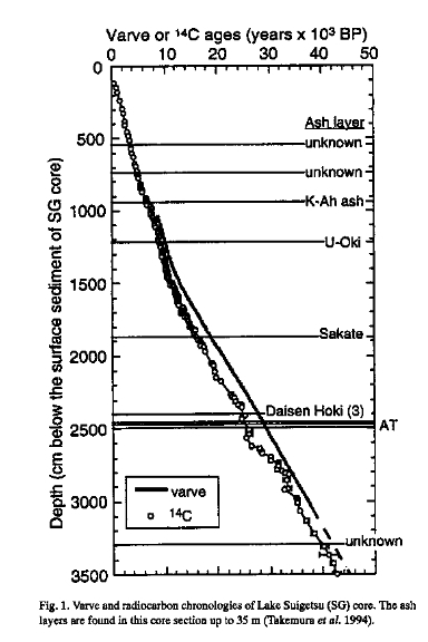
Plotted here is varve count vs C14 age vs depth. You cannot explain any of this graph. Why would it be that when you dates the organic portion of some varves you find that they get older and older proportional to the depth. That is, specifically let’s say we are at varve count 20000, that layer, when you carbon date it gives you an age of approximately 20 thousand years. And then when we are at varve count 30,000, the age is approximately 30000 years. And to top this off, there are thin layers of tephra that we gently deposited on the lake interdespersed throughout the varve sequence. When you use potassium argon dating on those layers, you find that the dates match up once again. Once we figured out this pattern, it became possible to use the sequence of varves to calibrate the amount of carbon in the air in the past because the varve sequence is so reliable. Apparently you and answers in Genesis seem to be confused on this last point. we just don’t change the amount of carbon-14 in the air to match the varve sequence. There are other ways to calibrate the amount of carbon-14 in the air independent of varves. And the other ways converge on the same concentrations of C14. There is nothing circular about this and I wish that they would stop lying about that.
1 Like
Very descriptive. Sort of like " I don’t believe x so anything that confirms x must be wrong?"
As to settling of silt in varves, I live near a chain of lakes, and see first hand how long it takes for turbidity to clear after rain events. Small particles take months to settle out. The mechanism and timing of sedimentation is well worked out by direct observation and confirmed by historical data such as known volcanic eruptions.
3 Likes
Their results weren’t replicated, as shown in the paper I referenced earlier.
Uh, those guys are wrong about it being global. The Permian Triassic Boundary in Australia and in Kansas is non-marine. The Permian Triassic boundary in Oklahoma has numerous erosional surfaces below and at the boundary. This is continental. These guys are working in China and you can see from Scotese’s map that China is under water, and Arizona was underwater at this time when the marine. Kaibab limestone was deposited out there. Also, another evidence that it wasn’t global is that no Permian marine beds are to be found on the granitic shield for each continent. Northern Canada has no relict Permian strata, neither does the shield of Arabia. But I will leave this thread as I think your mind is firmly made up and one thing I don’t want to do is waste my time. have a good day.
7 Likes
Are you convinced that radioactive dating is calibrated and understood to such a degree as to be without any chance of being unreliable?
Well, there is a chance we are computer simulations, so I don’t think certainty is ever something science provides, but…
I feel the evidence is overwhelmingly in support of radiometric dating being accurate within it’s known limitations, and adjustments due to future findings are exceedingly likely to be minor.
6 Likes
No kind of measurement works on the basis of being “without any chance of being unreliable.” Measurement works on the basis of determining and quantifying its unreliability.
For example, the age of the earth is 4.54±0.05 billion years. That is, the inherent unreliability of the age of the earth is ±0.05 billion years, or ±1%. It could be as low as 4.49 billion years or as high as 4.59 billion years. Needless to say, 6,000 years lies far, far, far, far, far, far, far, far outside of that range.
4 Likes
I am again reminded of the differences in how scientists and non-scientists see data. Non-scientists can be skeptical of measurements that have error bars while scientists are skeptical of measurements that lack error bars.
7 Likes
The problem is that they haven’t been trained in the rigorous, exact way of thinking that science demands. To be fair, exact thinking isn’t something that comes naturally to most people. Your average Joe tends to think in terms of approximations, analogies, “that looks about right”, “common sense”, imagination, figures of speech and so on.
It never ceases to amaze me how often I hear non-scientists ask, “How can X be scientific? Surely if it’s science, then it should allow for multiple different opinions.” And don’t get me started on the boss that I once had who hired computer programmers entirely on the basis of what he thought of their body language…
3 Likes
Yeah, they don’t understand the difference between precision and accuracy.
Well put Matthew! May I add:
The evidence for an OLD earth presently includes:
- Two or three separate tree-ring series, each stretching back about 12,000 years. (Even Young-earthers like Aardsma, formerly with the Institute for Creation Research, have admitted that the evidence from individually carbon dated tree-rings in two totally separate tree-ring series on two different continents has cross checked the reliability of C-14-dating stretching back 12,000 years in time).
- Individually (C-14) dated varves in a lake in Japan, stretch back 40,000+ layers. (Green River varves have not been individually C-14 dated, but that would be an interesting experiment to perform since there are over 2 million layers per ancient fossil lakes in that region. And when you count the layers of all the fossilized lakes in that region, noting the lowest and highest layers in each lake and how the time overlaps in nearby fossil lake varves, there are over 6 million layers.)
- Deep ice cores feature 100,000 layers of ice — each layer having its own distinctive isotopic signature (and other types of layer-distinctive signatures as well), stretching back over 100,000+ layers.
- Evidence of extremely slow sea-floor spreading over 100,000,000 years. New sea floor is seen forming today from molten rock that emerges from a ridge that runs down the middle of the Atlantic ocean. On either side of that mid-Atlantic ridge, new molten rock continues to emerge, then it cools and hardens, and the date of cooling (as well as the direction and strength of the earthʼs magnetic field at the time it cooled) is sealed inside the rock in the iron crystals that harden there. Then the next strip of molten rock emerges from the mid-Atlantic ridge, cools, and hardens, as the continents on either side of the Atlantic ocean continue to drift slowly apart from each other. Thus are formed distinctive strips of sea-floor rock that run all the way from the middle of the Atlantic ocean (where the youngest radiometrically strips are) to near the shoreline (where the oldest radiometrically dated strips are found). Such strips of rock along both sides of the mid-Atlantic ridge reflect over a hundred million years of sea floor spreading that occurred as the continents of North and South American slowly drifted away from Europe and Africa. Moreover, the radiometric dates that stretch from the middle of the Atlantic to the shoreline, agree with independent measurements (both land based and satellite based) of the present rate of movement of North and South America away from Europe and Africa. The expected time it would take for the continents to move apart at their present rates of speed equals the data of the growing ages of the rocks from the mid-Atlantic ridge to the shorelines.
Even Young Eartherʼs agree that if you try, as they have, to explain the evidence for extremely slow sea-floor spreading simply by speeding up the process and imagining that the continents zipped into their present positions in a mere “year,” that hypothesis would require a MIRACLE to cool the molten rocks down instantly and in distinctive stages, and release just enough gas in the process to match the present rates of speed at which the continents are moving apart. Quite a MIRACLE too because if the continents “zipped” along, then the rocks and their radioactive isotopes would have run together like soft butter spread on microwaved bread, nor would the sea floor rocks exhibit the crystallization patterns that rocks exhibit that have cooled under conditions of much lower temperatures and pressures, which is what the sea floor rocks presently exhibit. Moreover, after the continents had ceased “zipping” along but slowed to their present extremely slow speeds, what odds would there be of achieving the same MATCH between the known range of radiometric dates of sea-floor rocks from the middle of the Atlantic to the shoreline, AND the present speed of the continentʼs moving apart from one another today? What a coincidence! The strictly scientific odds of an old earth look far better that the ad hoc young earth “continental zip” hypothesis. So, the continents most likely took over a hundred million years to separate, and at the same rate they are presently separating.
The evidence of an old-earth is enormous and defies the “odds.” There are thousands of individually dated tree rings — tens of thousands of individually dated lake varves — a hundred thousand distinctive layers of ice — and, sea-floor rocks formed in succession and having hardened over successive periods stretching back over a hundred million years.
3 Likes
How would this hypothetical zipping have affected the oceans? For example would it have caused massive tsunamis or something? And if so shouldn’t we expect to see some evidence of this or some other secondary effect on the oceans?
Probably so. Of course, not a single YEC practitioner has ever done a mathematical analysis of the geophysics to determine how much friction and heat would have been generated, what would have happened below the crust, what kind of geological formations would be observed afterwards, and so forth. You can just toss the question of what would have happened to the oceans and how high the tsunamis would have been on top of everything else that hasn’t been examined.
Yep. Insofar as the crustal movements would have been orders of magnitude greater than anything experienced in the past 4 millenia, the tsunamis would presumably have been orders of magnitude greater as well.
Unfortunately, Ken Ham could not introduce a mile-high tsunami into his theme park without voiding their insurance policy, so we will just have to keep speculating on how the ark and its inhabitants would have fared.
Best,
Chris
1 Like
The sea would have boiled away.
2 Likes
Oh yes! But that would have been the result of accelerated nuclear decay rather than accelerated plate tectonics.
Fun fact: Every living creature on the ark would have melted down from intense decay of radioactive K isotopes in their bodies.
Best,
Chris
1 Like
Easy, potassium levels were different in the past. That’s just your uniformitarianism bias there. Or the decay just went out to the hidden, undetectable fifth dimension we are accelerating at 1.6x10^20 meters per second through.
1 Like
Even if that didn’t happen, you still have massive amounts of outgassing that would seriously pollute both the water and atmosphere. I doubt fish could have survived if they were swimming around in sulfuric acid.
1 Like