Did bones actually become fossilized in the sediments of "ancient" epeiric (inland) seas on continents?

I think you’d better go back and read what I actually wrote–and read more slowly this time, o.k.?

I said that subduction zones produce tsunamis. And the 30,000 miles of subduction zones along the Pacific coast, therefore, would spawn lots of tsunamis–probably, megatsunamis, to begin with.

Evidence for such tsunamis would be the ocean sediment loads found upon the continents.

" and many more features indicate that the sediment on top of the Sauk unconformity was gradually deposited over a huge amount of time"

So, which Sauk unconformity are you referring to? There is an unconformity below it, and above it. The one below it is called “The Great Unconformity.” Are you referring to this?

This is also the unconformity–erosion zone–where the Sauk trangression eroded large boulders out of the basement granite. So, you are still contending that an ocean flow of “1/4 inch per year” would have the hydrodynamic power to work such erosion…even across most of the North American continent?

You argue that there is sufficient power in even that rate of spread, since even a small rise in sea level would be accompanied by “waves, currents, and storms.” But wait…now we’re not talking about “1/4 inch per year,” are we? You can’t put waves, currents, and storms into super slow motion the way you are trying to do with the Sauk transgression. Yes, the hydrodynamics of THESE ocean flows would indeed erode (and even carry sediment). But they are not at all flowing at only 1/4 inch per year!

This seems appropriate now since you’re too busy here to look at girdled rocks*… oh, it’s the second time I posted it (but we’re not talking about just whale bones anymore):

    The Defeat of Flood Geology by Flood Geology


*A question about the antiquity of the earth

Here, you make it clear you do not understand the Flood model. Sequence stratigraphy records greater and lesser marine transgressions–big flows and small flows…in succession (recorded as different “orders” of sequences–from 1 to 5). So, yes, one flow might simply drown a dinosaur (or herd even)–and it would even begin to decompose or be scavenged. Then, a following–much larger–sediment flow would completely bury the dinosaurs.

In fact, a good example of this was discovered by paleontologist Jack Horner in Montana, where a herd of 10,000 maiasaurs–after first decomposing–were then completely buried in flood sediments (he himself attributed it to a “catastrophic flood,” though not Noah’s). He and his co-workers found their bones disarticulated, even sorted, by the catastrophic flow.

So…who says some sedimentary layers were deposited “during, before, and after”? They were ALL deposited by the Flood. Who has said otherwise?

Yes, these are called higher order sequences–they are like tsunami pulses or waves of strong flows.

And this without disturbing the sediments below that have already fused why?

Wait. Mountains were not made up “of the same aged deposits” of ocean sediments. Where did you get that idea?

Now, when mountains–like the Laramide Orogeny–were pushed up, they already had ocean sediments deposited upon them, by earlier (paleozoic) marine transgressions. But the mountains themselves were not composed of ocean sediments–rather, they are composed of continental crust.

"If a massive tidal wave was responsible for silurian strata on the west coast of the US, then where did the silurian strata, which makes up mountains on the east coast, even come from?"

Tidal waves do not push up mountain ranges–plate tectonics do that.

Thanks for this, Phil. Very interesting.

Though, of course, I’m going to translate this into “Flood-ese,” saying the “varied water levels” were produced by pulses, waves, between major flows…so, not involving “long periods in between.”

"And I gave a pretty simple example before, where various forms of structural fracturing or otherwise features that are characteristic of the motion of lithified dense bodies of rock, predates things like erosion of Cenozoic strata by rivers. "

You are referring here to the Grand Canyon, right?

You speak of “Cenozoic strata”…yet there is no Cenozoic strata. In fact, most even of Mesozoic strata has been eroded. The rest is all Paleozoic strata.

The carving of the Grand Canyon is said to have begun during the Cenozoic (about 6 millions ago supposedly). But, again, the Grand Canyon does not contain Cenozoic strata.

" The carving of the Grand Canyon is said to have begun during the Cenozoic (about 6 millions ago supposedly). But, again, the Grand Canyon does not contain Cenozoic strata."

It does contain Cenozoic strata. Explanation:

You’re still not addressing my comments. The issue is a matter of order. Erosion by the Colorado post dates structural deformation. And what do you mean there is no Cenozoic strata? There’s plenty of Cenozoic strata within grand canyon national park and outside or beyond the national park as well.

My response:
A. The grand canyon does contain Cenozoic strata.
B. The Colorado river doesn’t exist in a little bubble where it just stops existing the moment you leave a national park. And;
C. None of this addresses the issue of structural deformation predating erosion by the river.

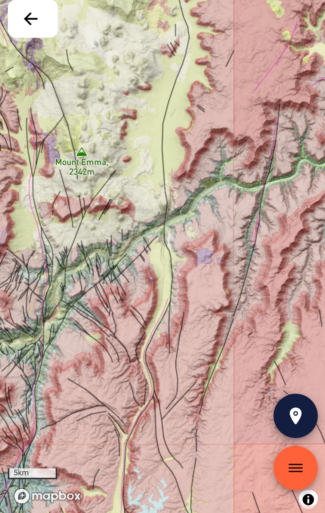
Let’s see if my image loads. Attached, in yellow, is some Cenozoic strata, SE if Mt Emma, within the national park.

Nobody should overlook this fact, what you just did is you argued something that was blatantly incorrect. You should stop stating incorrect information and spend more time asking questions.

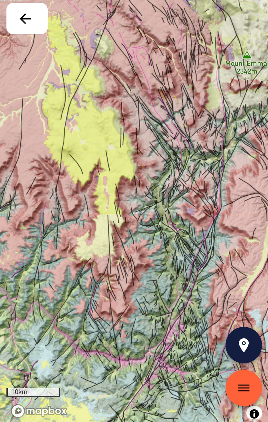
Heres another image over by the lake Meade recreational area. And again you can see in yellow, Cenozoic strata.

But again, the main point here is that erosion by the river post dates structural deformation of underlying strata. This is just a simple known fact, and it’s well known. It’s very well established and clear.

And this is a problem for people who think that all of this stratigraphy formed in some sort of rapid soft sediment washout.

And another note here, you can even see how there are fractures running through various periods of strata, further demonstrating that these were dense and lithified solid bodies of rock, prior to deformation and uplift, and further prior to erosion by the Colorado, as a product of that uplift.

And then you said something like "In fact, most even of Mesozoic strata has been eroded. ".

Well yea, and what time occurs after the mesozoic? the cenozoic. So if you have erosion of mesozoic strata, then you know that the erosion occurred after the deposition of that mesozoic strata. During the cenozoic. But still, just to keep pulling us back to the same original point that cannot be stressed enough, the erosional forces, the colorado river and wind erosion as well, post-date structural deformation observed throughout the paleozoic strata as a product of orogenesis. Uplift and fracturing occurs prior to lacustrine erosion and incision.

And this is a blatant issue for anyone who suggests that earth is a few thousand years old. And these features are observed worldwide. Its no secret or anything.

1 Like

But the scales of biblicism progressively fell from my eyes. Even against my will. With loss. Pruning. Purging.

How the ancients saw God in their primeval ignorance is not how He is, if He is. Neither nature.

Jesus was the greatest step in the right direction. That trajectory continues. Is facilitated by righteous weights and measures wherever they lead.

"And what do you mean there is no Cenozoic strata? There’s plenty of Cenozoic strata within grand canyon national park and outside or beyond the national park as well."

I said this based on the following quote:

Geology in the Grand Canyon - GrandCanyon.com

“Mesozoic and Cenozoic rocks (250 million years old to the present) are largely missing at Grand Canyon. They have either been worn away or were never deposited.”

But since then, in addition to your maps, I’ve read another article that said some Cenozoic sediment deposits exist, mostly in the western Grand Canyon.

So, I stand corrected on this.

1 Like

I’ve never said all the stratigraphy (of the Grand Canyon, you mean?) “was formed in some sort of rapid soft sediment washout.”

But Cenozoic sediments did result from the Tejas megasequence drainoff of ocean waters from the continent (just as the Flood model would predict). And so, these are the sediments you are describing.

Yes, much faulting (probably from uplift?) is evident in the Grand Canyon:

Faults - Grand Canyon National Park (U.S. National Park Service) (nps.gov)

Exposed in the walls of the Grand Canyon, are numerous faults that document the region’s earthquake – or tectonic – history. Since faults in the Grand Canyon are not only exposed on horizontal surfaces, but also in the walls of the canyon, geologists are provided with a rare opportunity to study what faults look like thousands of feet down into the earth’s crust. Faults are seen cutting through practically every geologic layer in the canyon, from the oldest, two-billion-year-old Precambrian rocks through some of the most recent lava flows less than 10,000 years old."

But Cenozoic (Flood drainage) sediments also exist, just as you’ve shown.

thank you.

I just have to tell you, and its not worth trying to debate me because right now im just informing you of the reality of the situation.

The simple reality of the situation, is that structural deformation pre-exists erosion of the colorado.

I know, it seems so simple, how could it be that professional YEC geologists overlook such a simple and blatant issue?

There is no explanation other than quite literally stated that “its just a miracle”. And thats where the response and discussion ends. Its evidence presented by the scientific community vs. closure of the discussion with omission and claims of a miracle.

And in every scientific critique or discussion you’ll find out there in the published world, that’s how the conversation plays out every time. And this is unfortunate, but thats just how it is.

3 Likes

So now im just going to circle back again to what ive been saying all along. I’m trying to keep us on track here.

So we have this fracturing, breaking, grinding, fragmenting, structural crushing and crunching of dense, solid, lithified, massive bodies of rock. These are solid structures moving, big solid structures that span thousands of square miles, and theyre in motion. They break and uplift.

Then…you have your colorado river, its cutting through the land as it uplifts. Fractures in these rocks demonstrate that they arent soft as the river cuts through them.

And so that leads us to this simple reality that, this valley cut out by the river, must have logically taken millions of years. Unless rivers across earth were made of some sort of supernatural hyper acidic fluid that slices through dense metamorphic rock like a knife through butter…but of course such an idea would come with its own bizarre logical conflicts.

And then you have your response from before that maybe the water was just high energy. And maybe just by some incredible devine force, this water just blew out the canyon in some extreme physics defying way. But again, as ive noted multiple times in past posts, we have many 180 degree meanders, suggesting not high energy water blasting rock out of the canyon, but rather a gradually developed river that in some cases even produced oxbow features, prior to incision through dense rock.

Such a situation just cannot logically be explained by anything but an incredible expanse of time.

And there is no response for this by any young earth professional geologist aside from public deferral to miracles.

2 Likes

From the same Sauk transgression that supplied the west coast.

Sauk Transgression - Plate Tectonics - Climate Policy Watcher (climate-policy-watcher.org)

And why do you think that disproves the Flood model?

Nothing has to. How does the Flood pseudoscience biblicist ‘model’ disprove science? Did you see my last post above?