“They cannot be produced by a single giant wave. There are hundreds of different zones…”
I have already addressed this–more than once: there are five different orders of sequences. Put another way, there are indeed many “sub-sequences” within each megasequence.
Notice this article, speaking of the high sea level during the Zuni (late Cretaceous, here). It accounts for this continental transgression as being caused by a high ocean level that was global (eustatic), so not as a result of any continent’s subsidence (which involves relative sea level).
Major transgression during Late Cretaceous constrained by basin sediments in northern Africa: implication for global rise in sea level
“These results indicate that northern Africa underwent significant transgression during Late Cretaceous reaching its peak during Turonian to Coniacian. This significant transgression has been attributed to the global high sea-level during this time.”
Bone beds have been found in what are today river channels. But that is not at all to say that it was flooding rivers that buried the herds of dinosaurs–who show evidence they were trying escape the rising flood waters (even leaving their young behind). While some of the dino’s were not all that big, some were 30 feet long and weighed 2 to 3 tons; it would have had to be pretty high and strong flooding rivers to overwhelm these guys!
But actually instead of attributing their mass burial to flooding rivers, authorities speak of “recurring coastal-plain flooding”–caused by tropical storms, even hurricanes. Yet, having directly experienced a flooding hurricane (even being flooded out of my house), I have trouble seeing a herd of these great beasts being mass drowned and mass buried in the flooding waters even of a hurricane (especially the dino that stood 13’ tall and weighed 6 tons in China). Think of Triceratops, who stood close to 10’ tall and tipped the scales at up to 13 tons! Can you imagine what kind of sedimentary water flow would be required to drown and bury him in sediment? Hardly a flooding river…or even a flooding hurricane!
Studies are showing that the flooding waters of the Late Cretaceous (the Zuni) were the highest ever of our earth’s past. But the flooding was not just local or regional. They speak of the high “global”–eustatic–sea level. That means these same continent-flooding waters were simultaneously flooding other continents as well–like Africa.
Studies in sedimentary layer thicknesses bear out the same truth. Thicknesses of the Zuni (Cretaceous) were the greatest on all continents–in fact, Africa’s Zuni thicknesses were much greater even than ours, here in North America.
However frantically you attempt to wave your magic wand and say the magic words – “Same evidence, different worldview!” – you cannot make these rabbits disappear into the hat.
You have quoted this out of context.
The quoted passage refers to a small part of the continent, not the entire continent!
Here, let me give you the full text:
During phases of uplift in the Columbian-Sevier orogen, great volumes of coarse-grained terrigenous sediments were deposited as clastic wedges in the western side of the basin. Lithofacies grade, west to east, from coarse-grained sandstone facies, through interbedded sandstone and shale, to shale, chalk, and ultimately to limestone. [emphasis mine]
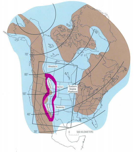
I have marked the map indicating the location of the basin in question.
The text on this diagram is completely illegible. There is no way to judge whether you are interpreting it correctly.
You are completely wrong to make this claim. The Transcontinental Arch has not always existed. As just one example: during the late Cretaceous, the area of what is now the Great Plains sank, and an inland sea separated stable platforms to the west and to the east.
"We have different gifts, according to the grace given to each of us."
I have every reason to accept your qualifications as a minister of the gospel, Don. That is your gift, and you exercised it faithfully for ~50 years. Thanks for that service!
Your claim to a gifting as a geologist, however, is – ahem – not as well established. You seem to be unaware of this, however many times your brothers, who love you, point it out to you.
You spoke of the arrogance of geologists, Don. You went there. Consider, then, how you yourself might be perceived when you implicitly make strong claims of geological expertise greater than that of thousands who have each labored for decades to obtain advanced degrees and domain mastery…
…yet you make obvious, silly mistakes based on an ignorance of the fundamentals and details of geology and paleontology. Do give this point some thought.
Blessings,
Chris
P.S. You have made 75 posts in this thread. Yet you have not been able to provide any mathematical, geophysical analysis of any of the things you have claimed. You’re batting zero-for-75. Can you see why readers of this thread would conclude that your implicit claim to expertise is unsupported?
He has not been able to give even a ‘layman’s description’ of how intact fossils are formed in multiple tsunamis without destruction, speaking of catastrophism:
Chris…you keep doing this. You are reading faster than your brain can think. I did not at all say that geologists are arrogant; I said that anyone who thinks they are too knowledgeable or too gifted, etc. etc. to be questioned or challenged in their teaching…is being arrogant. In fact, scientists are to be the very first ones willing to be questioned and challenged since they know that science, by its very nature, is designed to be a growing, self-correcting study.
And speaking of being corrected, I do accept (and appreciate, even) your correcting me by pointing out the context of the quote I used. I had the “west to east” applying to the whole continent, when the writer was actually applying it to a more limited area, this orogeny.
At the same time, if the study had addressed lithofacies farther east, I am confident it would have recognized that this facies (limestone upon shale upon sandstone) extends east well beyond this orogeny. I’m sorry the diagram didn’t work out (and thanks for pointing this out); however, it does indeed (if anyone visits the website they’ll see it) show sediment thinning from west to east, to the East Coast–which would not support the uplift/subsidence model.
You are being hyper-critical accusing me of representing myself as an expert in geology. To share on this thread what I have read, from the work of geologists, and to explain my takeaway from it is not claiming to be an expert. I haven’t double-checked, but I think Ron is the only professional geologist in this thread; and yet, the rest of you have expressed your thinking at least as confidently as I have, even admitting you are amateurs. Why is it, when I express my thinking, I’m claiming to be an expert; but when you and others in this thread are expressing your thinking, you are not claiming such expertise? It seems that you save your criticism only for those who disagree with you.
Dale, I am not wedded to tsunamis being the hydraulics that transported and spread about 53 million cubic kilometers of sediment across North America. So, what do you have in mind, that did it?
Many of the fossils contained in this sediment show amazing definition–like trilobite eyes–evidencing a very rapid and complete burial in muddy sediment (not a gradual burial over millions of years). On the other hand, there are also large “bone beds” consisting of graded, disarticulated bones. There are dinosaur “graveyards” that evidence dinosaurs trampling each other, as they were being overwhelmed and buried alive by flooding sediment. So, what would you say is responsible for this kind of sedimentary flow?
In other words, you have the very same data I have, to work with? So, bring it back to life! What was happening here?
That’s been covered previously, I believe, double entendre not intended.
If you can believe that fossil beds with that kind of “amazing definition” (and there are a lot of them) remained intact throughout your multiple churning and abrasive tsunamis within a year, then your imagination is more easily persuaded than mine.
Since you have responded to this question (finally!) – how about the others of mine that you did not respond to? I can only conclude that they were too difficult to answer. You can access them easily where right after your original post there is a row of profile photos with the number of respective posts each contributor has made. Clicking/tapping on one will yield a filtered result listing only that contributor’s replies.
Chris, why so dramatic here–even using italics? Besides, you and I are evidently reading different articles on this. You say the Transcontinental Arch ended during the Cretaceous. Yet, an article I read (“Transcontinental Arch–a pattern formed by rejuvenation of local features across central North America”) says, “The Transcontinental Arch has been described by many authors as a feature having significant tectonic influence during the Phanerozoic, although the location, magnitude, and even the timing defining the arch varies greatly among authors.”
So, this says the Arch still had a tectonic influence through the Phanerozoic–this would include not only the Mesozoic (which the Cretaceous ends), but also the Cenozoic. So, these authors say it still had influence at a time when you insist (even with italics!) it did not.
So, if I am “completely wrong,” then I’m certainly not the only one (“completely”)? And, of course, there is also the possibility that it’s you who got it wrong here–if these writers are right. In fact, the geological diagram I sent (which I meant to be more legible), does show a special thinning of the megasequence sediments where the Arch was.
So, would you classify this statement as evidence, or is it basically speculation?
“To err is human.” → Anyone – man, woman, or child – who commits an err is proving his/her humanity.
“To forgive is divine.” → Anyone – man, woman, or child – who forgives is exhibiting divine behavior.
“To say that a geologist can’t do his work effectively unless he is a uniformitarian… it’s just arrogant.” → Anyone – man, woman, or child – who says a geologist…
Please don’t blame me for your lapse in articulating yourself, Don.
You recognize that there is no contradiction between the passage you quoted and what I said, right?
Per the map of North America in the Late Cretaceous, sediment would not have circumvented the Transcontinental Arch because of the presence of the Western Interior Seaway. In other words, the Arch was not a barrier that sediment would have circumvented.
I do concede that I did not express this with geological exactitude. Though the Arch formation was at times underwater, it did not stop existing per se.
Relative sea levels fell multiple times, as a margin of land temporarily rose above the water along the ancestral Transcontinental Arch,[2] each time rejoining the separated, divergent land populations, allowing a temporary mixing of newer species before again separating the populations.
At its largest, the Western Interior Seaway stretched from the Rockies east to the Appalachians, some 1,000 km (620 mi) wide. At its deepest, it may have been only 800 or 900 metres (2,600 or 3,000 ft) deep, shallow in terms of seas. Two great continental watersheds drained into it from east and west, diluting its waters and bringing resources in eroded silt that formed shifting delta systems along its low-lying coasts.
Do you need any tips on posting a higher resolution photo?
There is an enormous gulf between our stances, Don.
I and others in this thread besides @rsewell are relying on the collective perspiration, ingenuity and expertise of tens of thousands of Ph.D. geologists. What we are writing in this thread is manifestly not based on anything other than our ability to read and report what the experts have written. As I stated in post #115:
TBH, I did not fully understand much of this paper because I am not a geologist.
Later in that same post, I wrote this:
I have come to the conclusion that it would take me years of effort to really grasp how plate tectonics models work, and why. You have lots of fun ahead of you if you choose to explore the topic in depth.
Or you could just be like me, and acknowledge that tens of thousands of geophysicists in academia and industry have very good reasons to believe what they believe, and they do a good job of checking on each other to make sure the works that get published are valid.
This to me seems like a pretty clear admission that I am not relying on my own expertise.
But make no mistake, what I and others have written in this thread is in full agreement with the consensus of academic and industry geologists.
I do not believe you can make the same claim about what you have written, Don. You clearly disagree with the broad community of experts who have been assembling their catalog of data and models over many generations. And so far as I can tell, you base your disagreements on your idiosyncratic interpretations of the data. And you feel free to claim that those who practice the consensus discipline of geology are wrong. On what basis does that claim rest, if not some source of greater expertise?
To the best of my knowledge, no “uniformitarian” (there’s that misused word again) geologist has said what you assert they have said. So far as I can tell, anyone who uses standard geophysics models in combination with the shared corpus of geological data can practice geology, regardless of whether they agree or disagree with doctrinal statements published by Answers in Genesis. Would you agree, @rsewell?
Now if one of those folks who practice geology chooses to live with the cognitive dissonance of also believing YEC flood geology, that’s their prerogative.
I don’t understand this statement of yours. An unconformity by definition involves the erosion of one or more sedimentary layers. Per an online geology textbook:
Unconformities are typically buried erosional surfaces that can represent a break in the geologic record of hundreds of millions of years or more. It called an unconformity because the ages of the layers of rock that are abutting each other are discontinuous. An expected age of layer or layers of rock is/are missing due to the erosion; and, some period in geologic time is not represented. [my emphasis]
And the text you quoted in post #28 states:
black areas represent major unconformities (sequence boundaries). [original emphasis]
There are a lot of black areas throughout geological history on the diagram you posted in #28. That means there was a lot of erosion happening throughout that the geological history.
Which means in turn that I do not understand how you came to the conclusion that “layers were not washed off the land.”
Pickup trucks can get carried off by 2 feet of water. Flooded rivers can easily get to 30 feet deep, and all it would take would be a bit of current dragging the dinosaurs under, or enough to exhaust them before they could cross. Also, dinosaur herds are extremely rare finds, as compared to marine mollusks, many of which are extremely small and fragile, and had to be deposited where they lived to be anything more than dust. As an example: a small juvenile Haminoea antillarum (1.35 mm)
Ask someone who has done core samples of the eastern coastal plain and they will tell you that there is only a few meters of sediment in the peidmont, 10s of meters in the sandhills, and 3 km near the coast. In general, sediment get thicker as the land gets lower.
@donpartain presented a graphic that he described as showing a certain layer’s sediment formations getting thinner moving from east of present-day Rockies toward present-day Appalachians. Based on what you have just said, the thinning of the sediment in that layer from west to east would imply that the erosion was flowing from east to west. Is that correct?
I have another correction to make (as I said, I make no claims to being an expert!). The thinning of sedimentary layers from the west coast was actually in a northeasterly direction, toward the Canadian Shield.
And, Chris, if you were offering to show me how to post that diagram in this thread, I will gladly take you up on your offer.
So, this diagram does show that the greater loads of sediment were deposited on the West Coast, then thinned as more and more of the sediment was deposited.
Timothy, I corrected myself on this matter–see my reply to Chris. The graphics in Clarey’s study actually show the sedimentary layer thinning going from a west to northeasterly direction, thinning toward the Canadian Shield.
The black-area unconformities are not missing layers “representing millions of years,” as uniformitarian geologists popularly claim.
Rather, they are erosion zones–just like the K-T (or K-P) boundary. Remember that each megasequence is bounded above and below by an unconformity; these erosion zones were caused either by the powerful transgressive flow of sediment across the continent (as was the case with the Sauk transgression–producing “the Great Unconformity”–or caused by the regression of the sediment flow.
Used the Windows Snipping Tool to capture the image.
Saved the image to my Pictures folder.
At this point, I could have simply uploaded the saved picture directly to the post. Instead, I decided to use it as the exemplar for a Google image search. On the first page of “similar picture” results, I found the high-resolution original on the Answers in Genesis site.
I right-clicked the image on the AiG web page and selected “Copy Image Address.”