I had asked for this thread to be reopened because I too may have been caught not believing the details of the Bible. I am going to present a minor alternative to the geography of Eden presented in the original post. In this post I am going to ask the reader to consider at least whether or not there was special information in this passage. While I won’t claim it, I do find it odd that the description provided can be used to describe a situation which hasn’t existed for at least 5 million years. To do so and to refresh everyone’s minds I am going to go over again the four rivers mentioned in Genesis 2.
Anyone who has watched my work over the years, knows I believe that god has been dealing with mankind since we were early hominids. On my blog and here, I have posted articles explaining in detail why the only time humanity could have had an original pair of parents was 5.5 myr ago and why intelligence is not related to brain size, etc. Most people want to still with a Neolithic Adam but the scientific evidence doesn’t support that. The oldest human genes are 5.5 myr old. Hominids appear on earth 5.5 myr ago. The Zanclean flood that matches exactly the description of Noah’s flood happened, 5.5 myr ago. But let’s look at the rivers.
And a river went out of Eden to water the garden; and from thence it was parted, and became into four heads. 11 The name of the first is Pison: that is it which compasseth the whole land of Havilah, where there is gold; 12 And the gold of that land is good: there is bdellium and the onyx stone. 13 And the name of the second river is Gihon: the same is it that compasseth the whole land of Ethiopia. 14 And the name of the third river is Hiddekel: that is it which goeth toward the east of Assyria. And the fourth river is Euphrates. The Holy Bible: King James Version. (2009). (Electronic Edition of the 1900 Authorized Version., Ge 2:10–14). Bellingham, WA: Logos Research Systems, Inc.
Let’s look at the rivers in backward order. It is generally believed that the Euphrates (Parath) is the Euphrates River, and Parath is translated 19 times as Euphrates in the Bible. It seems the identification of this river is true. So Eden involves the Euphrates.
The penultimate river is the Hiddekal and that is identified as the Tigris river. It seems certain to be correct because in Daniel 10:4 Daniel speaks of the Hiddekal river–and Danny boy is in Babylon. So, Eden involves the Tigris river.
I want to point out some things before we go on to the Pishon river. 5.5 million years ago, the Mediterranean sea was a dry desert. The northward movement of Africa had cut this Tethys ocean remnant off from the rest of the world’s oceans and in about 4000 years, all the water evaporated producing one very large desert except for the areas where rivers flowed into the basin. The Nile cut a 4500 m deep canyon into the African Granite just below Cairo. The Rhone River of France cut another deep incision into the European continent as it sped on its way to the bottom of the desert. Canyons were also cut into the Levant, but little was known of them, at least by me, due to the paucity of geological data.
Secondly, the Dead Sea Rift was not fully developed yet and the geology, topology and geography was all a bit different back then. Rivers don’t stay in one place forever, well at least most rivers don’t. So expect that 5.5 million years ago things to be different.
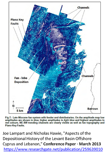
If you look at the Euphrates river today, you can see something very odd, It gets within 60 miles of the Mediterranean coast and then takes a right turn (few rivers in the world take such tight corners). Five and a half million yeas ago, it spilled into the Mediterranean desert and there is three dimensional seismic data to prove that.
The middle channel marked at the top of the seismic is a big river channel and it is emanating from the part of Lebanon where the Euphrates would have hit, had it continued to the Mediterranean coast today.
I don’t have seismic where the Tigris likely went so I can’t quite tie this up in a bow. It is a smaller river so it’s ancient channel would have been smaller as well. For all I know the southern channel on this 3d seismic slice might be it.
The Gihon is also hard to miss its identification with modern names. It encompasses Cush. Well, the Nile river splits into the Blue and White Nile. These two branches can be said to encompass ancient Ethiopia, which was a little less well defined than the modern country of Ethiopia.
That leaves us the Pison river which is said to compass the land of Havilah. And this is what I didn’t believe when years ago I laid out my views of Eden and the flood. At that time, very little geologic and seismic data was available offshore Israel and Lebanon. Within the past 10-15 years, major gas discoveries have been found on the Mediterranean sea floor, and such discoveries bring all the seismic contractors and consulting money’s to such an area and the geologic data rolls in. And last night it finally rolled onto my desk top.
In my previous views, I had held that possibly Havilah was a duplicated name, like Aberdeen, SD or Aberdeen, Maryland, or the true grey lady, and my home for 3 years, Aberdeen, Scotland which city has 22 shades of grey–grey roads, grey stone and grey sky!. But in reading the New Bible Dictionary I was reminded of what a couple of verses say about Havilah.
An area mentioned in the phrase ‘from Havilah to Shur’; inhabited by the Ishmaelites (Gn. 25:18) and Amalekites (1 Sa. 15:7). It probably lay therefore in the area of Sinai and NW Arabia.
Mitchell, T. C. (1996). Havilah. In D. R. W. Wood, I. H. Marshall, A. R. Millard, J. I. Packer, & D. J. Wiseman (Eds.), New Bible dictionary (3rd ed., p. 446). Leicester, England; Downers Grove, IL: InterVarsity Press.
Maybe I should have believed that Havilah meant Arabia. Last night after re-researching this area for the umpteenth time over the years, I found this from a 2019 conference abstract. Arabia was drained towards the Mediterranean at this time. That would mean, So was the Sinai:
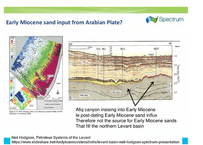
"Additional valleys of similar dimensions and characteristics to the marine extension of Afiq Canyon occur elsewhere along the continental slope of the entire Levant, suggesting that several rivers of the fluvial system of the Levant, which drained northwestern Arabia to the Mediterranean Sea during the Oligo-Miocene, still prevailed in the Messinian. The Afiq Canyon and its offshore apron as well as equivalents such as the Nahr Menashe fluvial system off Lebanon, imply that the geography of the Levant during late Miocene differed from the present. The Levant Rift could not have been a continuous tectonic depression as it is in the present, but rather a sufficiently disconnected series of grabens that allowed large rivers to still flow in between. The presence of the Afiq apron of substantial volume and with a thickness approaching 200 m along its apex confirms active fluvial systems feeding their bedloads into the Mediterranean as recent as 5 million years ago. ""View PDF
Yossi Mart and William B.F. Ryan, “The Offshore Afiq Canyon and its Messinian Evaporites, and Yafo Sand Apron are Indicators of Young Fluvial Systems Unimpeded by the Levant Rift”
So, I spent some time looking for a picture of this Afiq canyon and found a map of it from another conference:
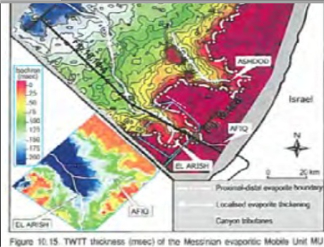
Below is an enlargement of the map in the above slide. It is fuzzy but you can see where Afiq is.
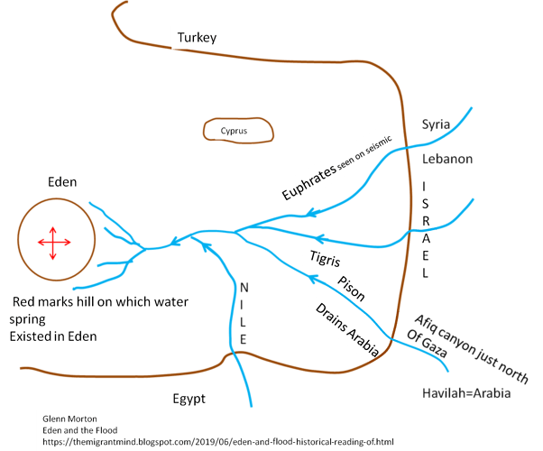
Because of this new information I would now map Eden’s geography like this, or at least this is an alternative view:
In the opening post I went into the mists arising from the land (an absolute must in this sunken Mediterranean world), and other reasons to believe its geology. I do think it odd that these verses describe a situation which hasn’t existed for millions of years. Such knowledge could not have been handed down by word of mouth that long. Shoot, in my family word that my Morton ancestors were quakers didn’t make it more than 4 generations from the immigrant. This knowledge would have had to have been divinely inspired, if indeed it is knowledge. But one thing I do know, 5.5 myr ago, the Tigris, Euphrates, Nile and Pison emptied into the Mediterranean and drained the areas described by Scripture. that is geologic fact!
I will point out a curious verse in Genesis 6 whose implications are not appreciated by either YEC or OE Mesopotamian flood advocate. Gen 6:13 says:
I will destroy them with the earth. The Holy Bible: King James Version. (2009). (Electronic Edition of the 1900 Authorized Version., Ge 6:13). Bellingham, WA: Logos Research Systems, Inc.
The word for earth is eretz. It is translated by YECs as planet earth–well the earth was not destroyed, it was rearranged by their flood. It is translated land by OE christians, but again, Mesopotamia was not destroyed by their Mesopotamian flood, it too was re-arranged. When the Mediterranean re-filled 5.5 my years ago, it took a year or so for it to re-fill, the rain would come from moist air being uplifted and pushed out of the basin,the waters would have literally covered what previously had been high mountains, and finally, the ‘land’ was literally destroyed. It is land no more.


