What were the conditions in the Dry Mediterranean Basin?
I am going to show how new data changed what I believed. It is important for anyone to follow the data. I had planned to post this yesterday but new (to me) and interesting data came to my attention… Here is the story.
I spent a lot of time building an atmospheric model for the Mediterranean. I made certain assumptions outlined below in the detail section, if anyone is interested, and was ready to present it. I had gone to some effort to determine that the basin was probably 3 km deep where Eden was. This is the summary.
I calculated temperatures for the bottom of the basin given a range of initial conditions. Going into this I felt that the biggest issue would be hellish temperatures. There is some Chickenwire dolomite on the bottom of the Med and that requires temperatures above 35C (95F). But this basin was so deep, deeper than anything on earth today, that I was very worried about the temperature. The ones I calculated would probably be close to daily maximums as it would cool off at night, and do so quickly if there was not much humidity.
I assumed a couple of reasonable temperatures for sea level during the Late Messinian and then used a variety of adiabatic lapse rates to calculate the temperature and the dew points. I had calculated the following. are:
| Lapse | Surface | 3000 m | 3000 m |
|---|---|---|---|
| rate | C | C | F |
| 9.8 | 288 | 316 | 107 |
| 9.8 | 300 | 328.5063 | 131.8942 |
| 7.5 | 288 | 310.2 | 98.94668 |
| 7.5 | 300 | 322.2 | 120.5467 |
| 5 | 288 | 303 | 85.991 |
| 5 | 300 | 315 | 107.591 |
The pressure down there would be 1.4 times our sea level atmospheric pressure.
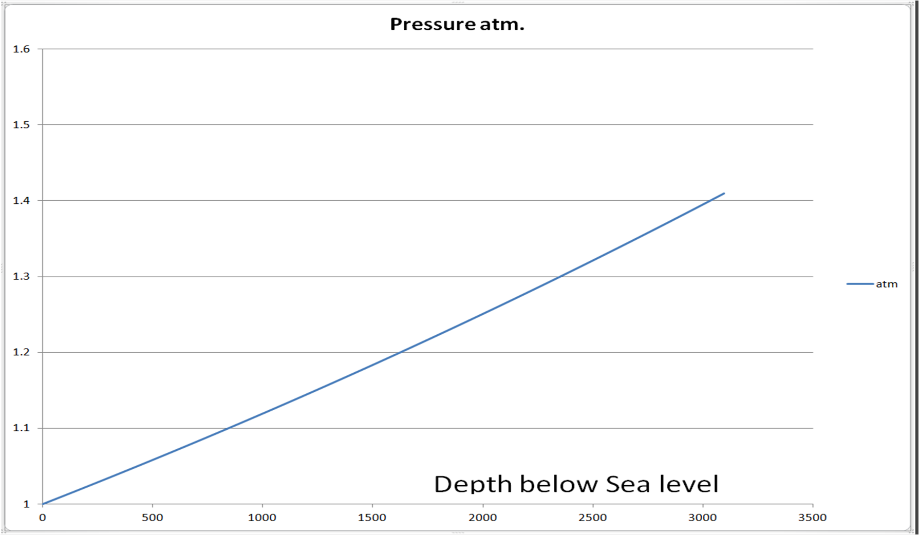
And no, the line is not linear.
I calculated dew points for how much uplift of the air by the infilling water it would require to cause rain.
For the temperatures calculated, I also calculated dew points at -3000 m for 50% relative humidity and 75% relative humidity. Basically at 50% RH, the air must be uplifted 2 km in order to reach dew point and cause rain. At 75% RH, the air needs only a 1 km uplift to reach the dew point and cause rain. If the water pouring into the basin saturates the air, then almost any rise in water surface would start the condensation of moisture out of the air. Rain would be an inevitable part of this process. I stand by that because that is simple physics.
Put a known RH air in a balloon and then walk it up a tall mountain at 7 m per day. I will guarantee that when that balloon reaches a dew point temperature, the moisture will condense. It can’t help it. Bill said a slow rate of fill wouldn’t cause rain, but the laws of dew point condensation a have nothing to do with speed. Also,Speed of uplift has nothing to do with the physics that happens to moist air at a dew point temperature.
I was ready to discuss a rather warm life in the basin when I ran into a surprise. Temperatures calculated from pollen and fossil plants, were a bit cooler and more temperate than other studies said, and so I expected. MAT is mean annual temperature. The rainfall was a little higher, but then, the plants are mostly in the higher elevations, meaning the Alps, The pollen and leaves would be carried downhill into the basin.
" For the post-evaporitic interval CAM reconstructions are available for Maccarone (Fauquette et al., 2006: ca 5.5 Ma to 5.3 Ma), where MAT is evaluated between 16 and 20°C for most spectra , but up to 23-24.5°C for a few others, with most likely values oscillating between 17 and 20°C (only one spectrum shows a lower MLV around 15°C). MAP is less stable along the succession. The first part of the sequence is characterized by large intervals, from around 400 to 1300 mm - MLV 1100 mm -, and smaller intervals from 1100 to 1300 mm, whereas the second part of the Messinian is characterised by more precise ranges from 700 to 1300 mm with MLV around 800 to 1200 mm ." Bertini A.; Martinetto E… Messinian to Zanclean vegetation and climate of Northern and Central Italy / - In: BOLLETTINO DELLA SOCIETÀ PALEONTOLOGICA ITALIANA. - ISSN 0375-7633. - 47 (2)(2008), pp. 105-121., p.117
Here is their 'Sketchy" reconstruction. We are interested in the Post evaporative Messinian. this is after the water from the Atlantic has been completely shut off.
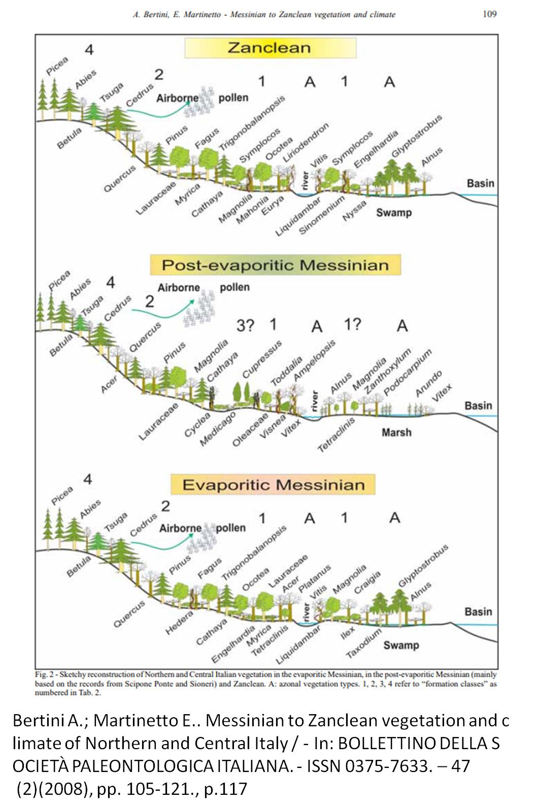
The fascinating thing is that this area of Italy was uplifted and was at a lower elevation when the Messinnian rocks were laid down. I went and looked up the mountains they mention as being uplifted at https://www.tandfonline.com/doi/full/10.1080/17445647.2017.1316218
The Bertini article cautioned:
" Of course, we cannot provide direct palaeoclimatic evidence for the palaeobotanically barren primary gypsum beds (Vena del Gesso basin), however it is curious that for all the clastic sediments adjacent to such beds we can definitely reconstruct palaeofloras and vegetation types which are never connected to desertic or subdesertic conditions ." Bertini A.; Martinetto E… Messinian to Zanclean vegetation and climate of Northern and Central Italy / - In: BOLLETTINO DELLA SOCIETÀ PALEONTOLOGICA ITALIANA. - ISSN 0375-7633. - 47 (2)(2008), pp. 105-121., p.119
So, I did a bit more looking at temperatures and found some interesting chemical estimates of temperature from air bubbles in the salt deposits. It was surprisingly cool down in the bottom of the basin where the halite was being deposited.
" In South America at latitude 47°S, till was deposited sometime between 7 m.y. and 4.6 m.y. ago, at a time when the local climate was colder than today’s . During this same interval glaciers extended to sea level in southeast Alaska, and widespread cooling of the ocean surface in middle latitudes, worldwide marine regression and change in the oxygen isotopic composition of ocean water occurred. From the last three events, major late Miocene expansion of the Antarctic Ice Sheet has been inferred, on the assumption that the history of North Atlantic ice rafting precludes the existence of Northern Hemisphere ice sheets until 3 m.y. ago. This is disputed, first because precipitation in Antarctica would probably have decreased at temperatures below today’s, second because the Antarctic Ice Sheet cannot expand appreciably until buildup of Northern Hemisphere ice sheets has lowered sea level, third because virtually no late Miocene sediments are present at the Labrador Sea DSDP sites that are critical to the reconstruction of North Atlantic ice rafting history, and fourth because the scale of late Miocene glaciation in Alaska is at least permissive for simultaneous buildup of ice at similar latitudes further east. If global ice sheet volume at the end of the Miocene was greater than it is today, by an amount that would have lowered sea level by several tens of meters, the excess ice did not accumulate in Antarctica, but in the Northern Hemisphere, chiefly in North America away from the Atlantic coast." J.H.Mercerab and J.F.Sutterab, “Late miocene—earliest pliocene glaciation in southern Argentina: implications for global ice-sheet history,” Palaeogeography, Palaeoclimatology, Palaeoecology, 38, 1982, p. 185-206
And then I found a direct measurement of temperatures down on the bottom of the Med and was very surprised:
“Taking into account both the present-day annual SST of the Mediterranean Sea around study sampling sites, which range between 18 and 20C , and the lower latitude of the Mediterranean Basin during the MSC, our homogenization temperatures point to a colder climate during the Messinian halite deposition, in comparison with the present interglacial climate stage. This conclusion is consistent with the Messinian SST of 16–18C estimated through indexes of coral richness in shallow-water carbonates from different sites of the Mediterranean Basin [Bosellini and Perrin, 2008].” Giulio Speranza, et al, " Paleoclimate reconstruction during the Messinian evaporative drawdown of the Mediterranean Basin: Insights from microthermometry on halite fluid inclusions, " G3, Volume 14, Number 12 11 December 2013, p. 5073
The halite deposition was down around 3 km or slightly deeper. This is where the surface of the remnant Mediterranean was, and it was much cooler than I could have imagined. Speranza et all calculated the surface water temperatures down in the basin by using fluid inclusions. If the water temperatures down at minus 3 km deep were 18-20 C, then that is 68 deg F, which is incredibly cold. So, what is the problem?
It turns out that Mercerab and Sutterab were correct, this was a very cold time on earth. The Messinian is 6 myr ago to 5.33 or the end of the shading.
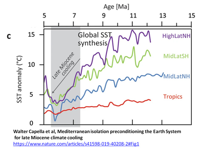
So, because of two oddities in earth history this time was one of intense cold which, would ameliorate the temperatures I had calculated above. Now, no doubt day time air temperatures were higher and what they calculated was average temperature, but this new information makes Eden a much more comfortable place than it otherwise might have been. Now I have to figure out how to incorporate this information.
Details of my calculations. .
Because the situation in the Messinian was so different from anything on earth today, it is natural to ask a question about what were the physical conditions at the bottom of this hole. We know a variety of large bodied mammals lived there so it couldn’t have been a true representation of hell. If it were that, they couldn’t have lived. The question revolves almost entirely around the depth of the basin at the time of Eden, and that has been the subject to much debate in geology. Thus, what I will present is my view of how that is answered.
There are some constraints on the depth of the basin. The Nile is said to have carved a 4+ km deep canyon in the granite platform of the African continent. This means it had to be that deep at some point during the crisis. It doesn’t have to be that deep at the time of Eden. Below is the topo map of the current basin. http://blogs.reading.ac.uk/oceansatreading/files/2016/05/Med_Topo_2.png
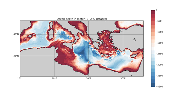
We are not interested in the deep areas of the central Med, but are interested in the area from Cyprus to the Nile and west of there, which is where I think Eden lay. It is said that the sedimentary thickness in this area is about 10 km
" The Levant basin contains over 10 km of Upper Jurassic through Cenozoic rocks that overlie a rifted Triassic to Lower Jurassic succession [Gardosh and Druckman, 2006; Netzeband et al., 2006a]. The southern and eastern flanks of the basin are cut by deep canyons of Oligocene and Miocene age [Druckman et al., 1995]." Madof, Andrew & Connell, Sean. (2017). Northern Levant basin (Seismic stratigraphy of a previously unidentified Messinian fluvio-deltaic succession: Implications for pre-Zanclean lacustrine flooding in the eastern Mediterranean). " In book: Seismic atlas of the “Messinian Salinity crisis” markers in the Mediterranean and Black Seas - Volume 2, Chapter: 17
What we need to do is remove the Pliocene through Cenozoic sediments and we will get an idea of the depth of the basin when it was dry. Yes, it would be a bit shallower than this because of isostatic adjustments, it does get us into the ball park.
We can do this by some depth sections taken from seismic. Like this section out from the NIle. It shows that in the Med, above the sale we have approximately 2 km of Pliocene-Cenozoic sediment–above the orangis Abu Madi and above the purplish salt.
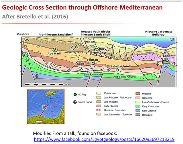
Looking back up at the bathimetry picture we are talking about basin depths for the Messinian surface of between 2200-3000 m deep.
A look at a seismic line off the Israeli coast shows 1 sec of Plio-Cenozoic section.
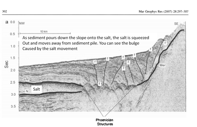
Such sediments generally have velocities of around 8000’/sec but, this is two-way time, so we have about 4000’ or 1.2 km or so. This given the pink is around 1600 m (not the steep slope) off the coast, then we are around 2800 m for the Messinian surface in this area.
So, knowing this, how hot was it down there? We all know of the heat in the Dead Sea and Death Valley. It all depends on how much humidity is in the air. The dry adiabatic lapse rate is 9.8 deg C/ km and the wet is about 5 deg C/km. The saturated lapse rate (at the dew point) goes down with higher temperature, and at high temperatures and one atmosphere it becomes as small as 1 deg/km for saturated air
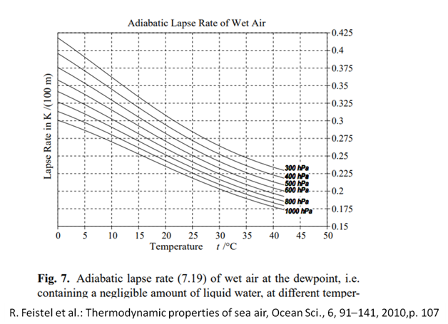
saturated adiabatic lapse rate (SALR)
The rate of cooling of ascending saturated air. It is approximately 1.5°C/1000 ft but may reduce to as little as 1°C/1000 ft in the warm saturated tropical regions. It also may exceed 2°C/1000 ft when the temperature of the air falls below the freezing point until it is no longer saturated and the lapse rate falls to that of dry air. Saturated adiabatic lapse rate | Article about saturated adiabatic lapse rate by The Free Dictionary
Non-raining lapse rates are generally in the area of 5-7 deg C/km.
Here is what I calculated using sea level temperatures. Remember, these would be the hottest temperatures of the day, not the average temperature.
| Lapse | Surface 0 m | -3000 m | -3000 m |
|---|---|---|---|
| rate | C | C | F |
| 9.8 | 288 | 316 | 107 |
| 9.8 | 300 | 328.5063 | 131.8942 |
| 7.5 | 288 | 310.2 | 98.94668 |
| 7.5 | 300 | 322.2 | 120.5467 |
| 5 | 288 | 303 | 85.991 |
| 5 | 300 | 315 | 107.591 |
I grew up in an area that had 115 deg days while I was there. it was miserable but even outside if one had shade, one could bear it so long as one had water. We didn’t have air-conditioning when I was a kid. My parents either couldn’t or wouldn’t afford it.
For the temperatures calculated, I also calculated dew points at -3000 m for 50% relative humidity and 75% relative humidity. Basically at 50% RH, the air must be uplifted 2 km in order to reach dew point and cause rain. At 75% RH, the air needs only a 1 km uplift to reach the dew point and cause rain.
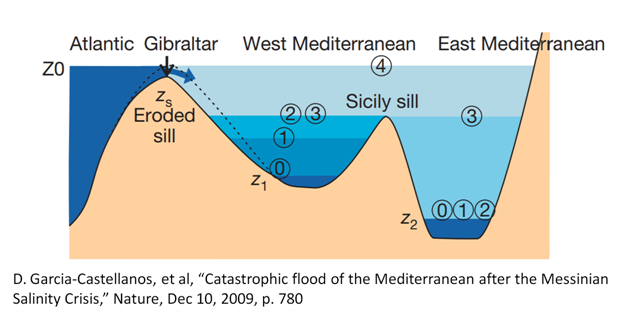
Now, the western basin of the Mediterranean was filled with water to -400m prior to when the eastern basin started filling. It had to top the Sicily sill first. The water pouring into the basin at as fast as 200 mph would quickly take the relative humidity up to near 100% which would mean, dew points were reached quickly there and it had rained for months before the process started in the eastern part of the Mediterranean.
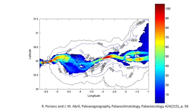
When the eastern basin started filling, again the velocities of the water approached 200 mph. See below, 100 m/s is 223 mph. This would create turbulence.
I know it has been challenged that it would rain with a 4-10 m/day rise in the water surface. It was asserted I believe that the slow rate of uplift would not cause rain. I think I can push back on that. Take a balloon and fill it with a known humidity of air, where you know the dew point. To claim that such a slow uplift would not cause condensation and rain is equivalent to saying that if you moved that balloon up a mountain at the same rate that when it got to the dew point temperature, the water would not condense on the inside of the balloon. Such an observation would mean that in addition to temperature alone, some other physical processes would be required to condense the moisture. Such a discovery would be big, but it would require a different physics for condensation NOT to occur.
Thus I do claim that this constant uplift of now fully saturated air would cause a very long rainstorm the likes of which the earth has not seen since.