Did Noah's Flood Kill All Humans except his family?

I really meant to be away from here for at least a month, Debate wastes so much time especially if one knows that the other guy is just throwing rocks for no reason. (this is a good place for that if one doesn’t hold the popular view). Anyway I spent my time running from Covid, researching and writing for my blog, and I needed a break from this place of great doubt about the reality of the Bible. I guess God had a different plan for me so I am back for a bit. All my life I have tried to figure out Noah’s flood. As a geologist, I know floods leave evidence of themselves, and there is zero geologic evidence for a flood in Mesopotamia–the popular site for Noah’s flood. What I have absolutely fits the story of the bible. So let the nitpicking, unbelief and doubt begin. I will stay until I am arguing about how many angels are dancing on the head of a pin like I felt I was last time.

Glenn R. Morton March 25, 2020

Let’s be real here. This story is an embarrassment to liberal Christians and held to dearly by young-earth people, who are also an embarrassment to ‘scientifically minded’ Christians. The young-earthers, I believe correctly, think the Bible stories are true, or at least true in large part. Proclaiming the Bible to be myth undermines its credibility as a book telling us the true path to salvation. There are two great divides we must cross between these two groups. The first is the extent of the flood. Was it local or was it global. The second is, was it anthropologically universal, that is, did it kill all humans save Noah’s family?

Let’s start with the verses I believe are wrongly translated, or translated with the translator’s bias. The issue revolves around the meaning of ’ eretz’, My favorite author as a young Christian said:

" According to Young’s Analytical Concordance, the Hebrew word is translated Country 140 times, Ground 96 times, and Earth and Land frequently. It is also rendered Field once and by several other words in a very small number of instances. Assuming that Young’s list is exhaustive, actual count shows that the word is translated Earth about 677 times and translated Land 1458 times. Moreover, of the 677 occurrences in at least 100 instances the word may be equally if not more appropriately, rendered Land rather than Earth. " ~ Arthur C. Custance, The Extent of the Flood, Doorway Papers, 41, (Ottawa: Privately Published, 1958), p. 3

With this in mind let’s look at Genesis 6:17

and every thing that is in the earth shall die

The modern mind thinks of planet earth when we see that word, but the Hebrews understood the word to mean land/country, not a ball in space. While I know the evidence is against the concept that they believed in a flat earth with domed sky, I don’t think they thought in our terms when they saw ’ eretz’.

Every other use of the word “earth” in the flood passage could equally be translated as land. I will say this. One can’t get the extent of the flood from Scripture alone. Land could mean all the land in God’s creation which, today, we would say would be a global flood. But if it is to be translated as land, as I believe, then the flood could be local. And this brings us to the mountain and universality problem.

Young-earthers rightfully note that the flood account does seem to indicate that the flood was anthropologically universal and they would point to the ‘high mountains’ mentioned in Gen 7:19. They argue that no local riverine flood could cover high mountains. And they are correct. Unless one changes the words of the Biblical account, one shouldn’t deny reality here–Noah’s flood is said to have covered high mountains. I don’t believe in having a make believe Bible of my own making in order to have a flood of any kind just so I can say I have a flood. We have to deal with the reality that the flood covered high mountains…

So how about universality? There are only two ways one can have an anthropologically universal flood. First, have a global flood. As a geophysicist, I spent 15 years in my 20s and early 30s struggling to fit what I was seeing in geology into a one year global flood. I will guarantee anyone that the geologic data won’t fit that scenario. But, all is not lost for those of us who wish to have a historical Bible. The second way to have an anthropologically universal flood is to have the flood at the start of humanity, when they were in a localized place. This is the approach I take.

So, our criteria require that we find a local flood capable of covering high mountains, when humans first appear on earth. I guess we need to define human here. I define humans as anyone who carries the image of God. That means they have a human-like consciousness. What they look like is of no concern, nor is appearance an indication of whether they lack or have the image. Brain size is not necessarily a requirement to carry the image of God. My wife had a Downs uncle who had a very small cranium, yet he was fully an image carrier. No, he couldn’t do physics, but he did love the Lord. I know this isn’t an objective criterion and is not easily applicable to fossil man, but there are some things that are indicative of Adam and Eve being extremely old. Among others, the evidence can be found here here

Amazingly there is a flood which is capable of fulfilling all our criteria. It is the Mediterranean infilling which happened 5.3 myr ago. It was a cataclysmic flood. The Mediterranean had dried out and become largely a desert but with lush areas where rivers flowed into it. Interestingly,one of the suggested origins of the word ‘Eden’ is the Akkadian word for desert Rivers like the Nile, the Pison, the Tigris and Euphrates. The basin was as deep as 5 km, When it filled in, the waters covered mountains as high as 5 km. That is 15,000 feet. If that doesn’t qualify as a tall mountain, then I don’t know what would qualify.

Why do I believe this is Noah’s flood?

  1. It is the only flood in earth history that matches the Biblical description exactly.

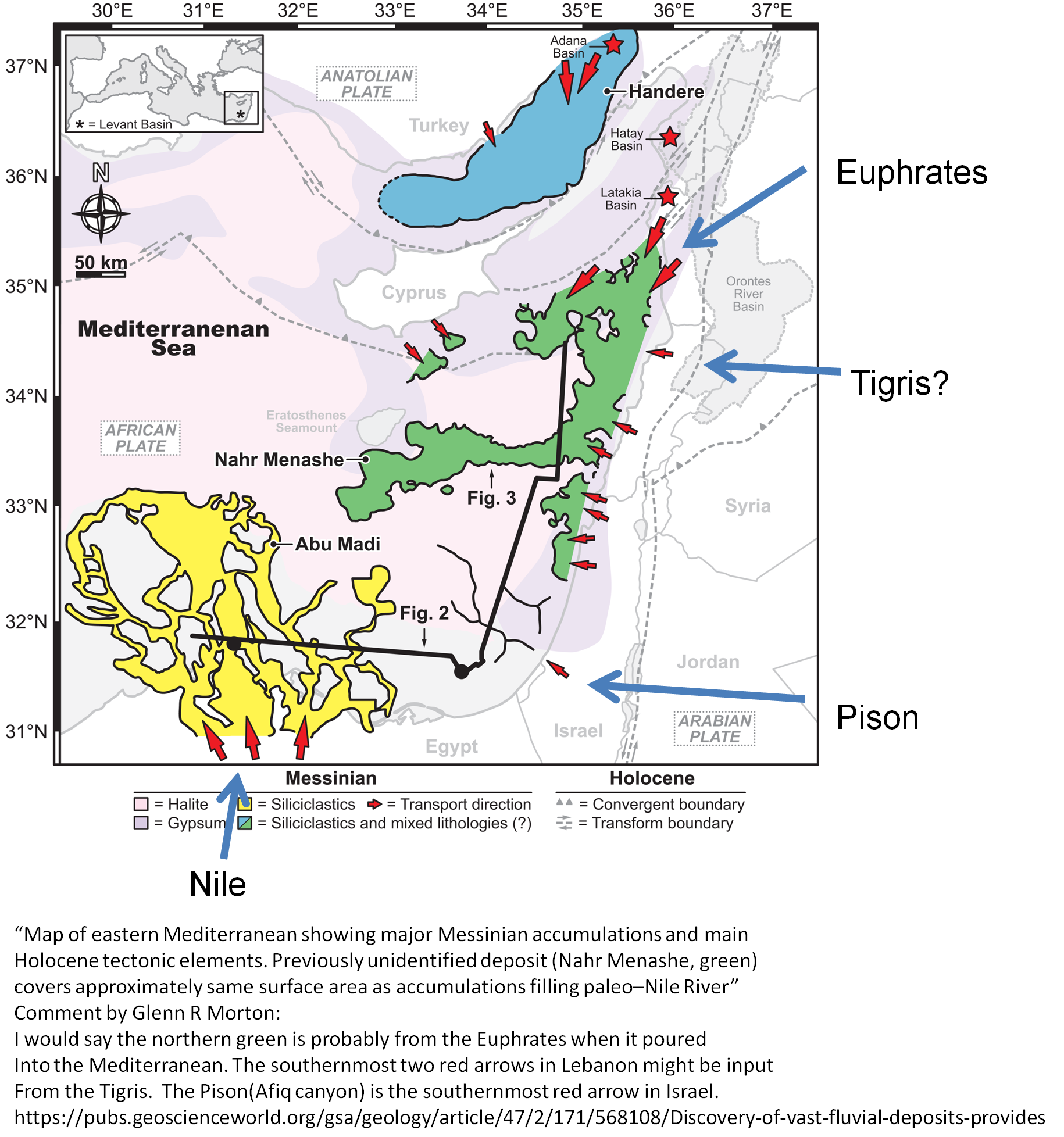
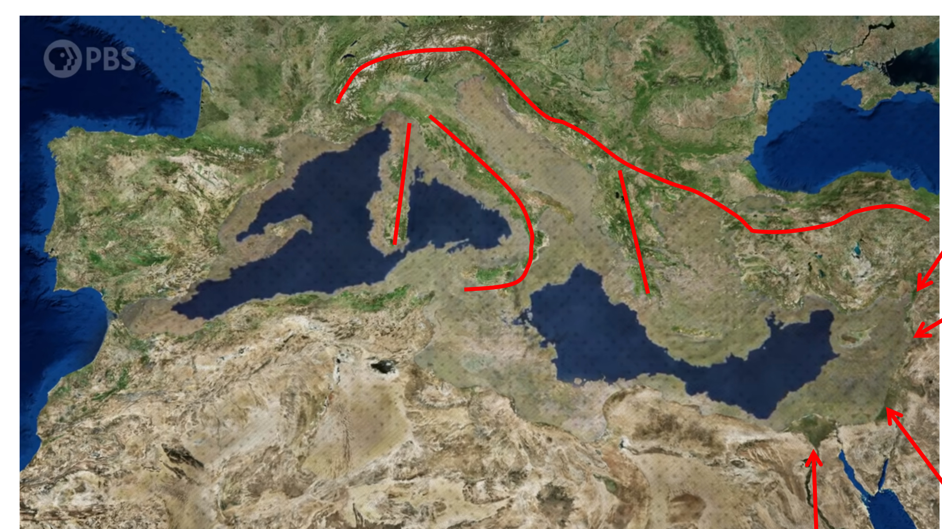
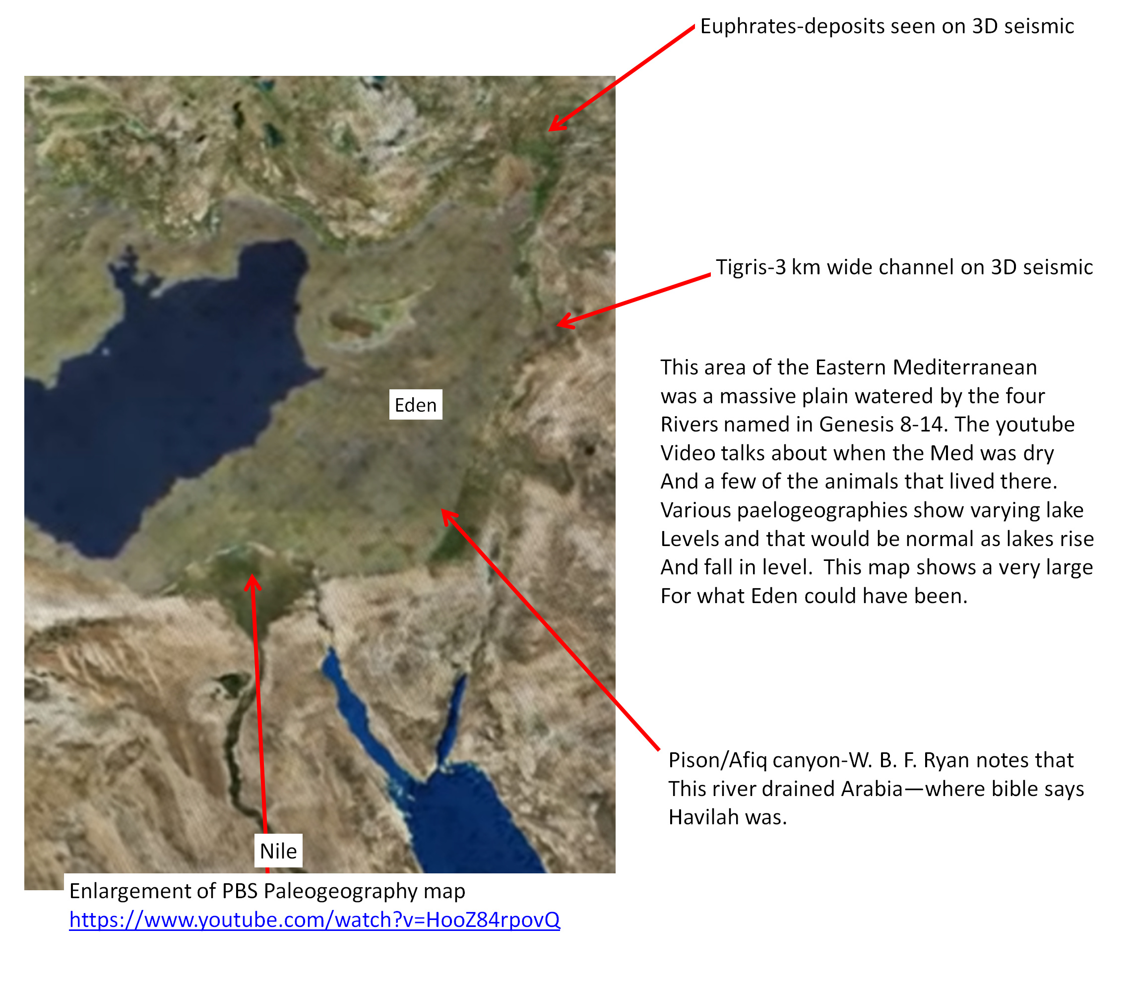
  2. Only at this time did the rivers of Eden flow into the same place. It is amazing to me that the Biblical description of Eden is an exact match for the geography of 5.3 myr ago in the eastern Mediterranean region… The Tigris and Euphrates, the Gihon which encompasses Cush can only be the Nile, and the Pison which flowed out of Havilah which the Bible places in Arabia, all were in Eden. Their positions are marked on the PBS map below showing the locations I believe they entered the basin in based upon interpretations of 3D seismic data shown in the literature. That a river was at each of these locations is certain. One could of course squabble about the name. They do match what Scripture says about Eden.

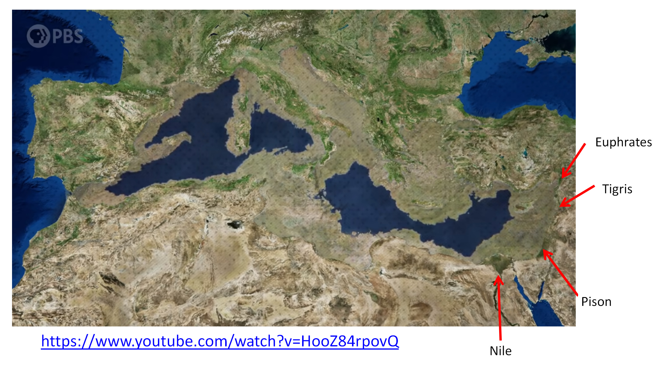
Below is an enlargement of this map showing what would be a huge area on the desert floor lushly watered by four different rivers. The area from the lake to the Levant coast is absolutely huge, but, as I said, would have been watered by 4 big rivers each of whom was mentioned in Scripture. The sediment from these four rivers would have created a land of intersecting deltas and built up a land gently sloping to the brine lake. It would have looked much like southern Louisiana only larger, and as with the Okovango delta in the Kalahari desert, much wildlife would have flourished there (see PBS video at end) or see my list in this Biologos post.
!


3. It was just at the time when the earliest hominids appeared on earth. The earliest known as of this writing is A. kadabba dated to 5.6 myr. A flood at this time, when humans are brand new can be anthropologically universal and the theology of the young-earthers can be correct. If all the humans are confined to that basin, then when the flood happened, they all died. One doesn’t have to reject Noah’s flood as myth if we place the flood in the Mediterranean basin at this time.

  1. One couldn’t easily walk out of this area so an ark was necessary. The Mediterranean basin is huge, an equal distance from one end to the other the same as crossing the USA. As air is pushed out of the basin, it would have created weird air fronts at the tops of the basin as the evicted air pushed outward away from the basin, and I feel certain it would have rained all around the rim of the basin, again making it difficult for someone to walk to safety.

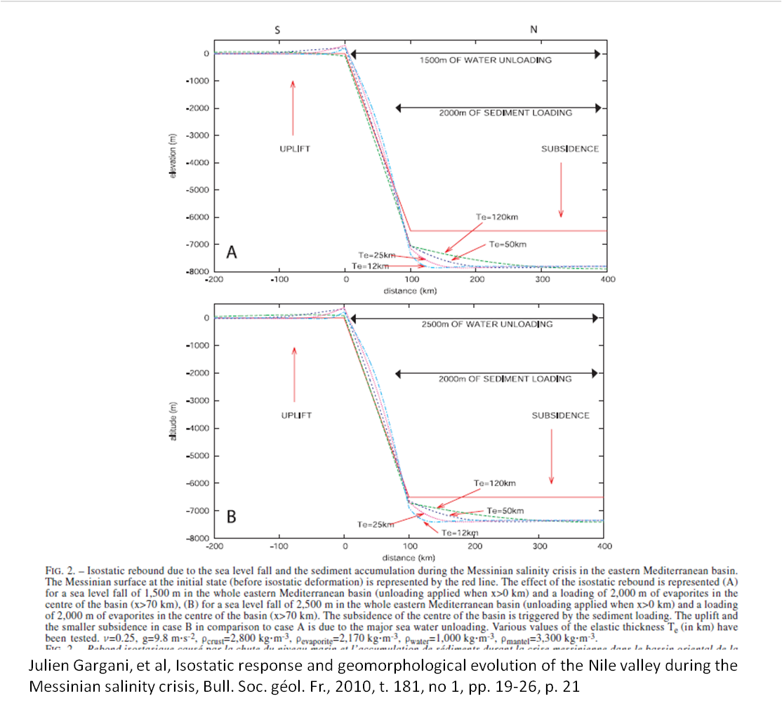
  2. It covered high mountains. This is the only local flood ever proposed that could cover 15,000 foot high mountains. Gravity models of the basin strongly suggest it was that deep or even deeper in parts. Note that in the model below they place the original Messinian surface, the red line in both models, at 7 km below sea level. Even after 2 km of salt is deposited, the depth of the basin would be more than 5 km below sea level.

  3. Modeling of fluid flow shows that, depending upon how large the breach in the Gibraltar dam was, it would fill in between 8 months and 2 years.

Interestingly the western part of the basin would partially fill before the eastern Mediterranean even started filling. It is estimated that the eastern Mediterranean would require about 200 days to fill after the partial filling of the western basin. This is quite close to the 150 days of water prevailing recorded in the Scripture.

  1. An object floating on the waters could have easily landed in southern Turkey, which the Bible calls the mountains of Ararat!. The Bible does use the plural for mountains, not the singular, so the Bible doesn’t say mount Ararat.

  2. Finally, I know of no other flooding event in geologic history that can satisfy the above check list.

There are several interesting short videos of what the infilling of the Mediterranean would look like. Come back after watching. There is a bit more to say. video 1 This second video also models the Black Sea but it has been proven that the Black Sea was never dry. video 2 . Below is another fluid flow model showing the velocity of the water. The top of the scale is near 223 mph (100 meters/second)!


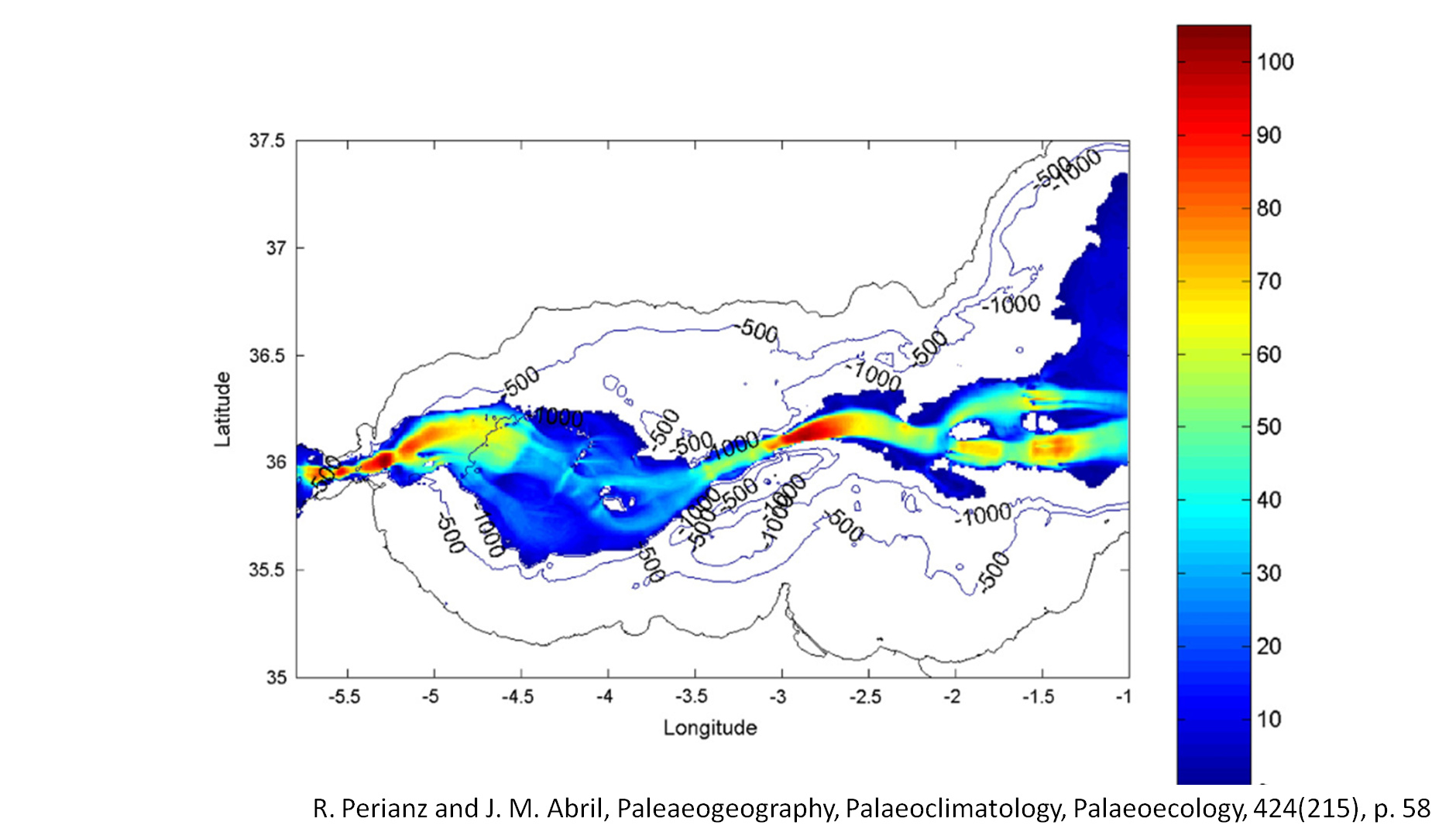
The second video has a much larger influx of water and by day 14 had started filling the eastern Mediterranean. Smaller openings in another fluid flow simulation says that the western basin would not start filling until day 400, but it would take 200 days to fill the rest of the basin. As noted above this if close to the 150 days of waters prevailing.

If the Biblical account is from Noah’s viewpoint, in this latter modeling, he would not know that the Gibraltar dam had breached for a long time after the catastrophe was certain. He would enter his boat (not the size of young-earth views), and stayed there until he landed in Turkey.

This flood matches exactly what the Bible says happened. The only impediment to its acceptance is resistance to the idea that Adam is old, resistance to evolution, and belief that the Scriptures are merely myth. I guess the question is, do you want the Bible to be historically true or not? Given the state of our geological knowledge it certainly can be real. For my part, I believe it was real. My faith is in Jesus Christ alone, but my belief that this is real is based upon real scientific data that matches the Bible’s description of Eden.

postscript. The PBS video is excellent and will explain much about this event. It is 11 min long but it is a good 11 min. It can be found here.

What are liberal Christians again?

It definitely does not undermine any credibility if there are mythological elements to the story. We’ve been over this before where you can have Aesop’s fables that carry great lessons and truth to them despite being entirely made up. I’m not saying that’s the case for Noah’s Flood but even if it was, this statement is not true.

Sort of. The thing is that if we are talking about “exact” things which the Bible seems to not really be doing in many places (e.g. the numbers are more “theological” than meant to be “literal”), at best you could claim that the Bible’s details can be within the error bars of geological calculations but we really couldn’t be so precise as exact days perfectly rounded to things like 150, 400, or 200.

That’s good. I probably would guess that if someone believes the Bible is telling us exact scientific details, they necessarily find some details that match. For example, I mentioned the abundance of the molecule of water in the universe and then one student proposed that that’s what it was talking about on day 2 of Genesis where God separated the ‘waters above’ from the ‘waters below’ by use of the firmament (which he thought to be our atmosphere). In other words, when we have the prior belief that it is giving us historical details, that’s exactly what we will read into the text. The only problem is that despite your eloquent presentation here, lots of people will be just fine reading other things into the text which was a major challenge as far back as the 1700s in Britian.

  • While there are some details in the text, there were diverse and conflicting applications of the relevant texts, i.e. the fountains of the great deep had been linked to the abyss, comets, the ocean, water from caves, etc.
    • Some had a growing suspicion the texts were being used improperly…
    • The sense grew that Scripture provided no single, incontestable, infallible diluvial scenario…
2 Likes

Pevaquark, glad to hear from you. After we had that tussle about my quoting people I hadn’t heard from you. I thought I had offended you by defending the use of my lifetime 1 gigabyte database of scientific information.

Ok, Let’s define liberal christianity as Wiki does. Doesn’t that seem fair?
Liberal Protestantism developed in the 19th century out of a need to adapt Christianity to a modern intellectual context. With the acceptance of Charles Darwin’s theory of natural selection, some traditional Christian beliefs, such as parts of the **Genesis creation narrative, became difficult to defend. Unable to ground faith exclusively in an appeal to [scripture]**(Religious text - Wikipedia) or the person of Jesus Christ, liberals, according to theologian and intellectual historian Alister McGrath, “sought to anchor that faith in common human experience, and interpret it in ways that made sense within the modern worldview.” Liberal Christianity - Wikipedia

I would guess many people here would not defend the creation account, nor the reality of the Fall, nor the reality of Noah’s flood–at least that is my experience. I hope this answers your sincere question. It is a sincere answer!

Given my match to both biblical data (the words contained in the account) and modern geology, I would be more interested in your comments on the fit of data to theory. Nitpicking about who is or isn’t a liberal christian is really kinda off the point–Please don’t miss the point of this article, that this account doesn’t have to be considered mythical. You are a physicist. Doesn’t a theory that matches facts have more weight than one that doesn’t? Calling Noah’s flood ‘mythical’ means none of the facts are matched with anything.

It definitely does not undermine any credibility if there are mythological elements to the story. We’ve been over this before where you can have Aesop’s fables that carry great lessons and truth to them despite being entirely made up. I’m not saying that’s the case for Noah’s Flood but even if it was, this statement is not true

.Yes we have been over it before. For some reason no one seems to understand simply logic of this issue. If god is so clueless and doesn’t know what happened on earth and is incapable of communicating to us the story of Noah and other things, then it is quite reasonable to ask, as many of your physicist colleagues and my geophysicist colleague do, is this God really there? I bolded Aesop. see below.

Now yes, I know people will say God didn’t intend to tell us anything real. I would like documentation of where anyone was able to determine what God’s intent is when for 1700 years everyone on earth thought his intention was to tell us a true history. What happened in the 19th century that gave mankind knowledge of what God intended? I am just asking for documentation of this belief–that is not an unreasonable request.

Sort of. The thing is that if we are talking about “exact” things which the Bible seems to not really be doing in many places (e.g. the numbers are more “theological” than meant to be “literal”), at best you could claim that the Bible’s details can be within the error bars of geological calculations but we really couldn’t be so precise as exact days perfectly rounded to things like 150, 400, or 200.

Sorry Pev, I didn’t say those numbers ‘matched’. the 200 days comes from a numerical fluid flow model of the Med and I said, if you would read it right, that it is awfully close to the 150. As you are clearly aware, in a model one can tweak the inputs to even match the 150 days by letting the opening be slightly bigger. But matching in a model doesn’t = truth This theory very well might be wrong, but, it is the only one that can check off the 7 points I laid out. and the 150 days was not one of those check points. It was something i found interesting. Tell me how the Mesopotamian flood does against that list, Please.

That’s good.
I am glad you approve. Your belief in the virtues of quantum are based upon the exact same criteria I use for this view of the flood—it matches observational data. Don’t use two different standards, one for what you like and one for what you don’t like.

I probably would guess that if someone believes the Bible is telling us exact scientific details, they necessarily find some details that match.

Not so. This assumes every possible scenario can be matched to the scientific data. I doubt you would say that YECs match much of the scientific data. If I am wrong in this assertion, please tell me where they match the scientific data.

For example, I mentioned the abundance of the molecule of water in the universe and then one student proposed that that’s what it was talking about on day 2 of Genesis where God separated the ‘waters above’ from the ‘waters below’ by use of the firmament (which he thought to be our atmosphere). In other words, when we have the prior belief that it is giving us historical details, that’s exactly what we will read into the text. The only problem is that despite your eloquent presentation here, lots of people will be just fine reading other things into the text which was a major challenge as far back as the 1700s in Britian.

I will agree with you in two points-- 1. Yes people will still be reading Aesop’s fables into the Bible after this presentation and 2. I do have to ascribe the names of the rivers to particular depositional systems. However, the northern Euphrates system obviously captured anything flowing off of Turkey close to the coast. Even today the Euphrates is only 60 miles from the Mediterranian coast.
.
The Afiq channel I do have to identify as the Pison, but it is in the correct place draining the correct land mass. The only river that encompasses Cush is the Nile. that seems easy. This leaves only the Tigris a bit loose, but, 3d seismic data does show a BIG river coming into the Med just north of the Israel border.

Otherwise, what you are saying is basically a diversion. First off, every archaeological effort in the area of Biblical Archaeology compares what the Bible says to what they find. That recent excavation in Sodom that found a meteor airburst had happened, compared what the Bible said to what they found. That is standard practice for them. The discoverer of Troy used the Iliad to find it–Did he ‘read things into what he found?’

Secondly, You are saying this without having looked at the data that OTHER geologists have collected and published. I can’t make the geologic data say what I want it to say. I didn’t 'read into the data, a major depocenter coming out of Hatay province Turkey at 5.3 myr ago called the Nahr Menashe. and another depocenter coming out of the Nile at this time called the Abu Madi. Here is that data–I just believed the data the other scientists collected. Sources for this can be found here

This seismic data shows a 3km wide channel coming off the Levant shelf in what became lebanon 5.3 myr ago. It is just north of the Israeli border,

And the Afiq canyon of 5.3 myr ago drains the arabian platform. Apparently at that time it was tilted toward the Med, not towards the Indian Ocean. The Bible says that is where Havilah was–in Arabia. I couldn’t ‘read that into the Bible’. I also couldn’t ‘read’ into existence a channel which drained the area of Havilah.
Yossi Mart and William B.F. Ryan Abstract

“The offshore extension of Afiq Canyon is a deep valley, buried under thick Plio-Quaternary sediments beneath the continental slope off the southern coastal plain of Israel. … Additional valleys of similar dimensions and characteristics to the marine extension of Afiq Canyon occur elsewhere along the continental slope of the entire Levant, suggesting that several rivers of the fluvial system of the Levant, which drained northwestern Arabia to the Mediterranean Sea during the Oligo-Miocene, still prevailed in the Messinian. The Afiq Canyon and its offshore apron as well as equivalents such as the Nahr Menashe fluvial system off Lebanon, imply that the geography of the Levant during late Miocene differed from the present. The Levant Rift could not have been a continuous tectonic depression as it is in the present, but rather a sufficiently disconnected series of grabens that allowed large rivers to still flow in between. The presence of the Afiq apron of substantial volume and with a thickness approaching 200 m along its apex confirms active fluvial systems feeding their bedloads into the Mediterranean as recent as 5 million years ago. View PDF

I didn’t read that description into existence. It is what they said. It matches what the Bible says about the Pison, which is located by the Bible itself via it’s own locating of Havilah.

I can assure you that in the 47 years of me generating theories of local earth history that many of my original ideas were totally disproven, sometimes by a well, sometimes by new seismic. But many of my views did pass muster with the data leading to a billion barrels of oil being discovered by the teams I managed. This theory is no different. If you want to disprove it, find contradictory geological information and lets have the debate. But please don’t think I don’t know the scientific craft I honed for 47 years. This is exactly what I did for a living, except for the theological part.

Thee is more evidence. I will discuss the strange hydrology of Eden and how it relates to this. Good theorys have facts fall into place. This is a good theory.

  • While there are some details in the text, there were diverse and conflicting applications of the relevant texts, i.e. the fountains of the great deep had been linked to the abyss, comets, the ocean, water from caves, etc.

Ah, lets look at the fountains of the deep. The deep (t’hom) often refers to deep waters, the ocean etc. So, what would you call it when the dam at Gibraltar broke and the waters of the Atlantic ocean (t’hom) broke through and the oceanic waters poured into the basin at 223 mph or more? Would you disagree that this event (see below for numerical model of this) could be described as “the fountains of the great deep burst open”(Gen 7:11)? The red is 100 m/s. You can check my conversion to mph.

I would call this event the fountains of the deep breaking open even if it had nothing to do with Noah. I didn’t ‘read’ into existence the 100 m/s velocity.

  • Some had a growing suspicion the texts were being used improperly…
    • The sense grew that Scripture provided no single, incontestable, infallible diluvial scenario…

If this is your belief, then it would seem to me that the term defined by WIKI above does apply to you. It doesn’t apply to me. Obviously.

You didn’t mention the rain. I just had a chance to ask my son about your idea. His response was “not even wrong “. The filling would not generate excessive rain. So you will need to come up with a different way to read those verses.

BTW he knows what he is talking about. His dissertation was on modeling severe weather, is published, and does meteorological work for a large tech company.

1 Like

Lol, your son and everyone else thinks Im wrong. Maybe I am wrong, but I already came up with another mechanism which you totally ignored. I spoke of turbulence, differential heating, formerly dry air now having a water source–the infilling waters. if any clouds form you get differential heating. Turbulence is going to come from the 2 areas that have water traveling at 200 mph according to the numerical models. This turbulence will start convection, which will then affect wider areas. But Bill, As I said before. if you don’t like my idea. fine. I don’t feel particularly obligated to answer

I don’t know your son, and with all due respect, my experience with experts is similar to Tetlock’s study of expertise. We are ALL wrong when we spout opinions without data to back us up–that is why my posts are the most data filled posts on this place. Here is Tetlock

"In one part of this study, Tetlock asked experts years ago to predict outcomes on seven different issues. In 1988, for example, he asked 38 Soviet experts whether the Communist Party would still be in power in 1993; and he asked 34 American political experts in 1992 whether President Bush would be re-elected later that year."
“After the events occurred, Tetlock then re-contacted the experts to ask them about their predictions. In all seven scenarios, only slightly more than half of the experts correctly predicted the events that occurred. Still, even those who were wrong had been quite confident in their predictions. Experts who said they were 80 percent or more confident in their predictions were correct only 45 percent of the time.”
http://www.scienceblog.com/community/older/1999/C/199902734.html

Fortune commenting on Tetlocks work said:
Which is not to say that experts are no different from you :! and me. They’re very different. For example, they’re much more confident in their predictions than nonexperts are, though they obviously have no reason to be. For example, the members of the American Political Science Association predicted in August 2000 that a Gore victory was a slam dunk.” Geoffrey Colvin, "Ditch the “Experts” Fortune, Feb 6, 2006, p. 44

those same experts said Hillary was a slam dunk–might there be a bias in their analyses?

Further, if you knew how many times with successful oil wells experts were wrong. Here is my best/worst example. When I was Exploration Director for China, we hired the industry expert on basin modeling. She worked for all the companies and made big dollars. Her opinion was highly valued. We had her look at a prospect we were interested in drilling. When I took over China, my company and the managers before me had not had a successful exploration well in 3 years and I was told 'find oil or we are sellling China." We found something that had all the seismic signatures of an oil field. But some wanted a basin model done so we hired this expert. She was telling me there couldn’t possibly be oil there. I asked about the inputs to her model. Her thermal gradient was gulf of Mexico gradient. I showed her articles in the Chinese literature saying the thermal gradient here was hotter. She wouldn’t budge. I showed her a 50 million bbl oil field in this basin–she wouldn’t budge. Her report said we didn’t have a chance in hades of finding oil --the basin was never deep enough or hot enough to form and migrate the oil. .
My company said they wouldn’t fund it unless I could sell it to another company to fund it totally. So, I went on a trip selling this thing and a company bought it for 40 million dollars, paying for two wells on two prospects. I told the buyer of this issue with modeling, but all I had to do to prove the modeler wrong was to point to that 50 million barrel oil field in the same basin about 10 clicks south. We drilled the well and found oil shows in the target. They did a MDT which tries to suck oil out of the rock–6 1-liter bottles or so. Nothing came out. The experts at Schlumberger said the rock was so bad not a single thing would flow out of that rock. The numbers they gave were almost those for granite(0.02 mD/cp)… I knew that we had used water to drill the well, and water makes the shales expand. Expanded shales plug the pores, so I begged the engineer to move the MDT and pull on the rock for a longer time than normal with a higher pressure differential than normal… She told me it wouldn’t work. She had years of experience in China and I respected her. but she did what I asked… We did move it, and suddenly oil came out of that rock into the jugs after a longer than normal time… I called my boss in Houston, told him the results and that I wanted to do a day long production test on the well. He said, not until you look into those jugs and see that it is actually oil. There are infrared detectors downhole to determine the fluid but he didn’t trust them. We had to send Chinese marine police to get the jugs to our platform so someone could open one of them. It was oil. We then tried to cement the well. It was awful. We didn’t get a good cement job. We poured loads of cement down that well and it simply disappeared. My boss in China, the country manager, told me there was no way we would get a good production test. I begged him to at least try. We did and we got 1100 barrels a day of production–that was fantastic for that area. Every single expert said it wouldn’t work. I knew that rock was very porous and we had drilled it at 70 ft per hour–that is porous rock. Porous rock that has oil shows is something that needs to be tested. The experts were really looking at those facts.

So with your son, my guess is he has never modeled this exact scenario. His opinion is just an opinion without data. Here is a chance for him to get a paper out of it and for you to wave it at me. Let him model it and prove me wrong on the general uplift of the air out of the basin. It seems to me that your son is ignoring the fact that hot air with a sea under it can absorb lots of water. and then he is ignoring the laws of adiabatic lapse. As that high humidity air rises, the adiabatic lapse rate cools it beyond its ability to hold water, so it condenses on any nucleii available. This is simple fact. So have your son model this and report back with all of his input value for us all to inspect. The position he seems to be taking is that hot air with vast quantities of water pouring into the basin wouldn’t quickly saturate with humidity, and that after that, as it was expelled from the basin, being pushed up, that the adiabatic lapse rate and physical laws of meteorology were suspended. If that is your position. you are welcome to it, but that is why I don’t beleive your son’s dataless opinion…

I have been thinking about your ‘headwaters issue’ this is from my Strange hydrology of Eden post.

"In our world, one river doesn’t source four others. So what could this word ‘head’ mean? The Hebrew word means ‘head’, ‘chief’, or ‘principal’. Its definition says nothing about water, or headwaters. But some interpret that verse as requiring that this Edenic river be the source of the other rivers. Now, I had an interesting debate about the word ‘heads’, but the debate got me thinking and I figured a way to explain this if it does indeed mean headwaters. Notice that I have one green river flowing out of Eden and its distributaries, empty into the four other rivers. I am going to suggest that even if you require Eden’s rivers to be ‘headwaters’, a requirement not imposed by the Hebrew but by one’s bias, then there is a way to have these rivers as ‘heads’.

If our continent had first been settled in Oregon, and people crossed the mountains and found the Missouri river and gave it a new name, let’s say, the Toodles river, they would float all the way to Southern Louisiana on the same Toodles river. They would give names to each of the tributaries they passed and in this scenario, we would consider the headwaters of the Toodles to be in Montana and Wyoming, not in Minnesota. What I am saying is that what we call a river’s headwaters, is an accident of history. It was Henry Rowe Schoolcraft in 1832 who named the source of the Mississippi river. He called the lake which he decided was the headwaters of the Mississippi, Veritas Caput. He could have named any of the thousands of heads as the headwaters of the Mississippi. Below are all the possible headwaters of the Mississippi river

Any one of the above headwaters could have been called the head waters of the Mississippi, in other words, they are all heads of the Mississippi river."The Migrant Mind: The Strange Hydrology of Eden

Edited to add. Bill, I don’t think your son understands the vast size and area of this upward moving air. It covers almost a million square kilometers and every where inside that million square km, the air is rising EVERYWHERE. That is not a normal meteorological situation

No I told him what you think and you are wrong in his professional opinion.

No you don’t understand the physics of rising air. He does.

When he has a model showing I am wrong, let me know. As I pointed out, experts are not always right. the Special publication 2 of the American Association of Petroleum Geologists is a rare book. It was the results of a conference on Alfred Wegener’s theory of continental drift where all the geologists in this prestigious body–all the experts on geology in the US at the time, absolutely skewered Wegener’s theory. Below is an partial account–the full account it too long The point is, that in their professional opinions, Wegener was on par with cow patties.

Despite their general rejection of the theory of continental drift, scientists somehow could not quite lay it to rest. In November of 1928, Wegener was invited to New York to attend an international symposium sponsored by the American Association of Petroleum Geologists. He eagerly accepted the chance to explain his views, only to find that the few supporterd raised at the meeting were quickly drowned out by a chorus of hostile dissenters, who criticized not only his hypothesis but his scientific credentials as well. One after another, delegates to the symposium stood up to express, with crushing sarcasm, grave doubts about the possibility of continental drift. Some barely troubled to justify their rejection of the hypothesis; others demonstrated errors of detail and used them to discredit the whole theory; a few seemed unable to restrain their anger that the idea was being seriously considered at all." *
"Professor Rollin T. Chamberlin of the University of Chicago attacked Wegener’s geological evidence on 18 separate counts, claiming it ranged from unlikely to ludicrous. "Wegener’s hypothesis in general,’ he said, 'is of the footloose type, in that it takes considerable liberty with our globe and is less bound by restrictions or tied down by awkward , ugly facts than most of its rival theories
.”
Russell Miller, Continents in Collision, (Alexandria, VA: Time-Life Books, 1983),p.49-52

One guy was convinced that Wegener was ignoring the demonstrably proved shrinking earth theory–which was a theory back then. Group think and bias can cause one to ignore data and be on the wrong side of history… Again, My posts are full of actual data that people can look at. Where is your data ? You have basically said your son is He-who-can’t-be-doubted. Give me data showing I am wrong, like I am giving you data saying I am correct, and we can have a real scientific debate. . Until then it is nice to know your son has an opinion.

By the way, you have ignored the turbulence issue I raised last time we debated and in my penultimate reply to you. You have also ignored my response to you ‘headwater’ issue you felt was so important last time we debated. Do you never acknowledge points the other guy makes? I spent some time thinking about 2 of your criticism already --the headwaters and the arrangement of Eden down in the basin. At least I pay attention to what you say. Do you give me the same courtesy?

lol, in response to you last point. I was trained as a physicist. Of course that doesn’t mean I know all areas of physics, but I do study very hard the areas I post on–and again, I show the data I base my conclusions on–you don’t. Your son doesn’t. It doesn’t take a genius to understand the adiabatic lapse rate, and the fact that the spray alone from these 200 mph streams of water would quickly humidify the air at the bottom of this desert. I will stand pat on my view-- As I said, you are welcome to defend the idea that the adiabatic lapse rate didn’t apply in that basin. It is what you are defending you know.
Here is a picture of the adiabatic process Note that as the air, humidified by the ocean, travels upward, rain falls. What a concept…

Didn’t Sir Leonard Woolley find a 12-foot deep layer of sediment while excavating Ur that he attributed to the local flood described in Genesis?

“Woolley was one of the first archaeologists to propose that the flood described in the Book of Genesis was local after identifying a flood-stratum at Ur “400 miles long and 100 miles wide; but for the occupants of the valley that was the whole world”.[13][14]

[quote=“03Cobra, post:9, topic:42578”]

Didn’t Sir Leonard Woolley find a 12-foot deep layer of sediment while excavating Ur that he attributed to the local flood described in Genesis?

Yes sir, he certainly did that. But that layer, geologically was not wide spread. It didn’t even cover Ur which continued to exist

“Following its publication in 1929, his Ur of the Chaldees became the most widely read book on archaeology ever printed.”
However, subsequent trenching at Ur, in the neighboring tells that surround Ur, such as Abu Shahrain (biblical Eridu), and in those extending north to other equally ancient settlements, such as Tell el Oueli and Choga Mami, have invariably failed to encounter this same silt layer. After much probing by trench and drill to trace its extent investigators have determined that the surface area of the deposit was localized and perhaps only a single breach in a levee of the Euphrates River, forming what modern hydrologists call a 'paly deposit,'covering at most a few square miles of the lateral floodplain. No archaeologist today considers Woolley’s silt layer at Ur to be any more significant than a thousand other silt layers spewed from the two great rivers during and since the last ice age. None of these local floods apparently had more importance than any other in serving as a major divide in human settlement in Mesopotamia.” ~ William Ryan and Walter Pitman, Noah’s Flood, (New York: Simon and Schuster, 1998), p.55

Since Smith’s death, the search in Mesopotamia for the signs of a largescale catastrophe has suffered its ups and downs. A bright moment came in 1928 when Leonard Woolley chanced upon a thick layer of homogeneous silt in the ruins of Ur such as would have been laid down by an overbank spill of the nearby Euphrates River. Not long after, another deposit was uncovered upstream in the excavations of Shuruppak, the ancient city mentioned by the poet Sin-leqi-unninni in his Babylonian version of Gilgamesh. The reporting of these observations in the popular press stimulated the public’s imagination across Europe and North America until the much awaited confirmation failed to trace the deposits laterally for any substantial distance–indeed, even from trench to trench within a single archaeological site. Accordingly, the engaging idea that a single grand deluge had engulfed all of southern Mesopotamia fell from favor. What remained in its place, except for those who read the Bible as literally true, was the raw myth unpredictable, and sometimes devastating spring floodings of the Tigris and Euphrates rivers during the snowmelt in the Taurus Mountains, or to a figment of the human imagination distilled into a remarkably uniform account by the smoothing action of retelling by a hundred generations of guslars.” William Ryan and Walter Pitman, Noah’s Flood, (New York: Simon and Schuster, 1998), p. 247-248

Just so you will know that Ryan and Pitman are not alone in this belief, this is on the web:

"Woolley’s first test pit was very small, so during that and the next season he had dug a number of other test shafts, including an enormous pit, seventy-five feet by sixty feet and sixty-four feet deep. In this main pit, he encountered a deposit of clean, apparently water-laid soil up to eleven feet thick. Evidence of the Flood was absent from several shafts and uncertain or disturbed in a number of others. But in many, Woolley felt he had certain evidence of the Flood (1955).

Just slightly before Woolley’s initial discovery, S. Langdon and L. Watelin encountered smaller flood levels at Kish (Watelin, 1934). Although the Kish discovery actually predated Woolley’s find at Ur, Woolley published first (Woolley, 1929) and received the lion’s share of the initial publicity. Woolley, moreover, produced a highly successful popularization of his work in which the Flood finds were recounted in a manner that is at once simple, authoritative, and filled with references to familiar biblical materials (Woolley, 1929, 1954, 1982). The finds from Ur achieved and maintain a predominant place in the public mind.

Initially, some assumed with great eagerness that the flood levels at Ur and Kish were identical and provided marvelous evidence for a historical kernel of the Genesis Flood story (Peake, 1930), but the enthusiasm could not be maintained. The level of the great flood at Ur was sandwiched between remains of the Al Ubaid cultural phase, the last purely prehistoric period of southern Mesopotamia, and a layer of debris from the early Protoliterate period. The great Ur flood, thus, can be dated with a high degree of certainty to about 3500 BCE. Kish, however, produced evidence of two floods at the end of the Early Dynastic I and beginning of the Early Dynastic II periods, around 3000 to 2900 BCE, and a still more impressive flood dating to the Early Dynastic III period, around 2600 BCE. All three of the Kish floods were much later than the great flood at Ur. Watelin argued that the earliest of these three was the deluge of the Bible and cuneiform literature.

Within a few years, excavations of a third Mesopotamian site, Shuruppak, also uncovered a flood stratum (Schmidt, 1931). It is of particular interest because, according to the Mesopotamian legend, Shuruppak was the home of Ziusudra, the Sumerian Noah. (The Sumerian Ziusudra means “life of long days.” The Akkadian equivalent, Utnapishtim, is “he found life,” while the alternative Atra-hasis means “exceedingly wise.”) This flood level separated late Protoliterate and Early Dynastic I remains and dates from around 2950 to 2850 BCE. Perhaps, but not certainly, the Shuruppak flood may be equated with the earliest flood at Kish. No other Mesopotamian sites have produced flood remains of significance (Mallowan, 1964)" The Flood: Mesopotamian Archaeological Evidence | National Center for Science Education

So, how did Woolley estimate the size of this ‘flood’? It wasn’t from actually digging trenches over the 400 miles long and 100 miles wide, it was from estimating how deep he thought the waters had to be to deposit 11 feet of shale–(which can be done slowly). Here is what Woolley said:

Both at Ur and on other Mesopotamian sites there has been found evidence of local and temporary water action occurring at various times in history; sometimes this was no more than the effect of rain in an enclosed area, and never is there anything approaching what we found in our ‘Floodpit’. There, it can safely be said, we have proof of inundation unparalleled in any later period of Mesopotamian history. We were lucky to find it at all because a flood does not of course, pile up silt everywhere–on the contrary, where the current is strongest it may have a scouring effect; the silt is deposited where the current is held up by some obstacle. to settle this point we dug a whole series of small shafts, covering a large area, in which the depth of the mud differed considerably, and thus were duly plotted it was clear hat the mud was heaped up against the north slope of the town mound which, rising above the plain broke the force of the floodwaters; on the plain east or west of the mound, we should probably have found nothing. Eleven feet of silt–the maximum–would probably mean a flood not less than twenty-five feet deep; in the flat low-lying land of Mesopotamia a flood of that depth would cover an area about three hundred miles long and a hundred miles across; the whole of the fertile land between the Elamite mountains and the high Syrian desert would disappear, every village would be destroyed and only a few of the old cities set high on their built-up mounds would survive the disaster. We know that Ur did survive; we have seen that villages such as al 'Ubaid and Rajeibeh were suddenly deserted and remained desolate for a long or forever.” Leonard Woolley, Excavations at Ur," Routledge, 2013) p 35

But as we know, subsequent investigation showed that the various layers of shale were different ages and it wasn’t one massive river flood. I made sure to say ‘river flood’ because one guy N. A. Morner says the clay layer was due to sea level rise which inundated areas east of Ur. I don’t know the truth as I just ran into Morner’s article so I will look at it tomorrow.

In any event, the Mesopotamian flood has no high mountains to cover, pushed any floating ark into the Indian ocean in about a week so what is this about landing on mountains in turkey? I know of no riverine flood that has lasted a year. And one could walk to the Zagros mountains in a day or two. Why build an ark?

1 Like

The Hebrew word often translated “mountains” can also be translated “hills,” and often it is.

The Hebrew word often translated “earth” can also be translated “land,” and often it is.

In a flat land, a hill of 10 cubits would be a high hill.

According to the NET Bible translator notes, the Hebrew text actually says the water rose 15 cubits and covered the high (hills or mountains, same word). The text does not actually say the water rose that far above the hills/mountains.

And, according to the NET Bible translator notes, the ark landed on the mountains/hills (plural) of Urartu. If the ark landed on multiple hills/mountains, then a mountain the size of the more recently named Mt. Ararat in Turkey does not fit the text.

A local flood in a flat land with a few hills fits the text better than a planetary flood.

Also, the bird returning with an olive branch (too soon after the flood for an olive tree to have grown) further indicates a local flood.

Note that the air that is forced up a slope by prevailing winds generates rain. Not the situation you are proposing.

Note that the air that is forced up a slope by prevailing winds does not always generate rain.

As the local weatherman just said “It takes more than warm moist air to generate rain. It takes a front or an upper level disturbance to trigger rain fall.”

BTW I am limited to my phone so it is difficult to reply in-depth right now. I think I did reply to your creative translation for headwaters.

[quote=“03Cobra, post:11, topic:42578”]

The Hebrew word often translated “mountains” can also be translated “hills,” and often it is.

Absolutely true. But southern Iraq around Ur it is flat like southern Louisiana. It is a swamp. There are no hills. And besides you igorre the fact that such a flood would wash the ark into the Indian Ocean, so what is the point of debating about hills that don’t exist in this area when everything else is wrong about the Mesopotamian flood?

The Hebrew word often translated “earth” can also be translated “land,” and often it is

I pointed this out in my opening post. I don’t understand the point. I never said it should be translated ‘earth’.

I don’t think so, not in this setting. All the southern Iraqis have to do is look east and they will see real mountains, the Zagros mountains. They would know the difference between a 10 cubit mole hill and a truly tall mountain. I don’t think they would be confused about it. But again, why are you ignoring the direction of water flow? That alone should disqualify the Mesopotamian flood.

The game seems to be, ignore the elephant on the table and argue nits that don’t matter.

Agreed, but the question is, how high is the mountain? that is the missing piece of data.

Again, you re imputing concepts I never said. Go read the opening post again and find me mentioning Mt. Ararat! that all the YECs want. To refresh your memory in Point 7 of the opening post I specifically said:

Why I am having to correct your misreading of what I wrote I don’t know. It would be nice if people would actually read and understand what was being said before they raise what they think is a killer argument. So many people make assumptions that I must believe what the YECs believe. I don’t.

this is funny, Moist air forced upslope by prevailing winds causes rain, but moist air forced up slope by water filling a basin underneath it has different physics? Sorry, that is ridiculous.

Never said it always did. Sheesh, again I am having to point out what I didn’t say.

I didn’t post what I did here about the Toodle’s river, until yesterday so no you haven’t replied to it.

I do feel for you being limited to a phone. I wold hate that. My big fingers can’t hardly type anything correctly on a phone (but then, it seems you cobra and everyone else thinks I can’t type anything that is correct, even with a keyboard. :grin:)

BTW, I might point you to page 164 of Vol 16, No 3 of the Creation Research Society Quarterly. top link on this page. CRSQ 1970 to 1979

No one recalls this now, but I am proud of that article. It was my first YEC article and it was a calculation of the surface temperature of the earth under a 40 ft water vapor canopy. That idea had been popularized by Henry Morris. Jody Dillow had just gotten a TH. D from Dallas Seminary which was an examination of the vapor canopy idea. Jody said the earth would be 70 deg or so under that canopy. That was ridiculous and didn’t pass the smell test. So, on an old non-programmable Rockwell calculator I calculated pressures, and surface temperatures for such an atmosphere.

You, Bill, might look at the atmospheric physics presented there before again suggesting I don’t know the physics of atmospheres. I will admit to being rusty on the calculations presented in the paper, but not on the adiabatic lapse rate.

Why am I proud of that article? Well, Jody admitted his dissertation made a mathematical error. Creationists tried for a decade to prove me wrong and finally Kofahl wrote.

“Morton(1979) was apparently the first to conclude that the canopy would have made the earth’s surface too hot for human habitation (Kofahl did not calculate surface temperatures). Morton made a number of assumptions that greatly simplified the problem, and his surface temperatures are much higher than ours, but the general conclusion is the same: Life as we know it would not have been possible under a canopy of 1013 mb (1 atm), nor even with a canopy of only 50 mb. When other features such as clouds are added to the model, this conclusion could be modified greatly, however. Preliminary explorations with cloud layers at the top of the 50 mb canopy have shown significant radiation effects which lower the surface temperature drastically. Unfortunately, while the surface temperature decreases when clouds are added, so does the temperature of the canopy, reducing its stability.” ~ David E. Rush and Larry Vardiman, “Pre-Flood Vapor Canopy Radiative Temperature Profiles,” in Robert E. Walsh, and Christopher L. Brooks, Proceedings of the Second International Conference on Creationism, (Pittsburgh: Creation Science Fellowship, 1990), p. 238

As I recall he repeated my calculations and found one of the values in one table in error. Other than that, using my assumptions he couldn’t find an error. It was my paper that did the vapor canopy idea in at least for another 10 years. I don’t know if they have revived it by now. From 1980 to 1990, I was called about every bad name possible by creationists for that article. Then they finally said I was correct.

I don’t mind being called stupid ignorant and a literalist Yahoo on this Mediterranean flood idea for 10 years. I know the data supports it. But sadly, I won’t last 10 years to see people view it more kindly.

Why wasn’t there a Rainbow in Noah’s Pre-Flood World?

Glenn R. Morton March 21, 2020

There are two statements that Biblical scholars don’t often connect and liberals dismiss as ridiculous. I believe the Bible is a record of God’s interaction with mankind. And I believe that it can be scientifically/historically true, but not with the normal approaches taken by Christians. I believe that the events of Genesis 2-9 took place on a land that no longer exists, and that explains why these verses have appeared so troubling. Let’s look at the verses.

When the Lord God made the earth and the heavens— 5 and no shrub of the field had yet appeared on the earth and no plant of the field had yet sprung up, for the Lord God had not sent rain on the earth and there was no man to work the ground ," Gen 2:4-5

There was no rain on the land upon which God was about to place Adam, and this was a time before farming.

The second verse is Genesis 9:11

" I establish my covenant with you: Never again will all life be cut off by the waters of a flood; never again will there be a flood to destroy the earth.

I do not like the translator’s choice of ‘earth’ because ’ eretz means ‘land’, not ‘planet earth’. the land that was destroyed, therefore, could have been an area of earth that no longer exists, but actually did long ago, when man’s ancestors first appear in the geologic record. It was the Mediterranean desert.

But let’s look at the other flood theories to see if any of them can explain a land with no rain and no rainbow? The global flood idea has the entire world flooded. Because rainbows can be seen anywhere on earth’s surface today, including the driest area on earth, the Atacama desert, it is difficult to see how there would be no pre-flood rainbows.

Many global flood advocates say the rainbow was just given special significance, but to me that is like God saying to someone today, I make my covenant with you and I will set my grass upon the ground. It makes no sense because God didn’t do anything as part of the covenant.

The Mesopotamian flood is popular with many Christians who don’t believe in the global flood but want a real flood any way. The problem is, there is rain in Iraq and rainbows in the sky. So again, one must effectively have God take something that was already there and give it ‘significance’, but that isn’t very satisfying. Having God give significance to something already there doesn’t show his power to keep his part of the bargain.

The answer to this question lies in the idea that Eden existed in the Mediterranean Basin 5.3 myr ago. The details can be found in the here, but the world was different back then. The Mediterranean was cut off from the Atlantic ocean and it evaporated to 3 or 4 large lakes. So you will know this large desert is a mainstream idea, see Wiki and Wiki. The world looked like this:

Click to enlarge. Note that the Taurus mountains are the Mountains of Ararat. The four rivers mentioned in Genesis 2:8-14 are found flowing into the same region of this Mediterranean desert and what looked like a nutty geography to many Biblical scholars, like Ryle and Radday:

" For Ryle, ‘The account…is irreconcilable with scientific geography.’ Radday believed that Eden is nowhere because of its deliberately tongue-in-cheek fantastic geography ." John C. Munday, Jr., “Eden’s Geography Erodes Flood Geology,” Westminster Theological Journal, 58(1996), pp. 123-154,p.128-130

The above scenario, recognized by modern geology as real, says that those rivers once were together in the same area. Details here.

Would there have been rain in that 5 km deep, empty basin? Not likely. First, the Mediterranean waters were mostly gone and the brine lakes remaining probably had salt crusts limiting further evaporation (A. Debenedetti, Marine Geology, 49,1982, p. 94.). For this post I am adding a picture of a relatively thick salt crust over water in the Salt Lake area.

There is river water pouring into the basin but, even today it is not enough to keep the Med filled with water. It is truly a small amount of water in the grand scheme of things.

Secondly, the Mediterranean is located in the Horse Latitudes. Of them, it is written:

" Horse latitudes, subtropical ridges or subtropical highs are the subtropical latitudes between 30 and 35 degrees both north and south where Earth’s atmosphere is dominated by the subtropical high, an area of high pressure, which suppresses precipitation and cloud formation , and has variable winds mixed with calm winds. " Horse latitudes - Wikipedia

You can see the 30 deg line along the coast of Egypt.

Thirdly, there is a very sharp rain shadow in all directions. The yellow lines on Mediterranean map above are the mountain ranges that cause a rain shadow.

From Wiki:

"A rain shadow is a dry area on the leeward side of a mountainous area (away from the wind). The mountains block the passage of rain-producing weather systems and cast a “shadow” of dryness behind them. Wind and moist air are drawn by the prevailing winds towards the top of the mountains, where it condenses and precipitates before it crosses the top. The air, without much moisture left, advances across the mountains creating a drier side called the "rain shadow “.” Rain shadow - Wikipedia

In addition as the air flows down into the basin the relative humidity of that air drops, making rain even less likely. Britannica says of the descending air mass:

" As it descends on the downwind side of the range, it warms again and its relative humidity is further reduced. This reduction in relative humidity not only prevents further rainfall, but also causes the air mass to absorb moisture from other sources, drying the climate on the downwind side. The ultimate result is lush forest on the windward side of a mountain separated by the summit from an arid environment on the downwind side. " Rain Shadow | Encyclopedia.com

I am adding this which isn’t in my blog post. As a reminder of what a rain shadow is, here it is in simple pictorial form.

If you look at where the region I say was Eden was, it is in the rain shadow of the Turkish, Roumanian, and Alps mountains. Any moisture laden front coming due east from the Atlantic, first has to drop rain on Spain, then again it would lose moisture at Sardina and then Italy and then Greece, which when the Med was dry was a high mountain. I have marked the mountains in red.


As the air descended 5 km down into the Mediterranean basin, the relative humidity would seriously drop, more so than anywhere today on the present earth. Rain would almost be impossible in such a basin.

No rain, no rainbow.

As for your view that the flood would have washed the ark into the Indian Ocean, that is just one more item that shows the story is not literal history.

I think you misunderstood my point about the water rising 15 cubits. The text doesn’t say the water rose 15 cubits above the top of the hills/mountains. It says the water rose 15 cubits and cover the high hills.

With so many inconsistencies in the story, why do you think people try to make it literal history?

[quote=“03Cobra, post:16, topic:42578, full:true”]

As for your view that the flood would have washed the ark into the Indian Ocean, that is just one more item that shows the story is not literal history.

Cobra,what you wrote is unclear. It is only the Mesopotamian flood that would wash the ark into the Indian ocean. The Mediterranean flood would land the ark somewhere in the eastern part of the Med. Bible says mountains of ararat, Well, that is Turkey and I see that as good as any other place to land the ark.

To be perfectly clear, when the Mediterranean was dry, there was no water pathway from the Med to the Indian Ocean.

I think you misunderstood my point about the water rising 15 cubits. The text doesn’t say the water rose 15 cubits above the top of the hills/mountains. It says the water rose 15 cubits and cover the high hills.

Yes, I did misunderstand you. Hebrew has no punctuation so the sentences are somewhat up to the person. One could, I guess read it the way you do–but I think the artificial verse division is not letting you see an equally good option. Consider this Ge 7:19–20:New American Standard:

The water prevailed more and more upon the earth, so that all the
high mountains everywhere under the heavens were
covered; the water prevailed fifteen cubits higher

if this is the sense of the passage, then the ark privaled 15 cubits higher. Some suggest that this was the draft of the ark. If it hadn’t prevailed 15 cubits higher it would have grounded on something. Then the next sentence.
“And the mountains were covered”.

Most translations make each sentence an independent clause, but the NIV translates it the way I have advocated:

They rose greatly on the earth, and all the high mountains under the entire heavens were covered. 20 The waters rose and covered the mountains to a depth of more than twenty feet

With so many inconsistencies in the story, why do you think people try to make it literal history?

Your whole note seems to have taken my criticisms of the Mesopotamian flood as if they applied to my Mediterranean flood. Please tell me the inconsistencies in the Mediterranean flood. None of what you have said is an inconsistency for my view. Both views start with an 'M" but that doesn’t mean they are the same.

For Pevaquark, I would be interested if he would agree that the breach in the dam at Gibraltar, which resulted in a massive influx of Atlantic water into the Med could be described as the fountains of the deep breaking forth? The water was moving at 223 mph or more.

For cobra, of the shale layer at Ur, here is what that paper I found last night says:

"At around 5000 years BP sea level peaked in the Persian Gulf region at a level of +0.3 m as now determined in Qatar. This coincides with the famous flooding of the ancient city of Ur, originally interpreted as due to local changes in the fluvial system. We can now propose that, in fact, it was the sea level rise that triggered the fluvial reorganization and rise in ground water level that ultimately led to “the flooding of Ur”. Nils-Axel Morner, “The Flooding of Mesopotamia in New Perspective.” Archaeological Discovery, 2015, 3, 26-31, p. 26

By the field studies in Qatar, we have now fixed the regional maximum Holocene sea level in elevation (+0.3 m) and age (~5000 BP), and found that this event is likely to have driven the classical flooding of the ancient city of Ur.” Nils-Axel Morner, “The Flooding of Mesopotamia in New Perspective.” Archaeological Discovery, 2015, 3, 26-31, p. 30

But note, this criticism of the Mesopotamian flood has nothing to do with the Mediterranean flood concept.

I was describing what the translator’s notes of the NET Bible said about the Hebrew text. There were five Hebrew scholars who translated the Torah.

I have listed several in earlier posts.

They include the landing of the ark on the hills (plural) of Urartu.

As for the Med being empty, that appears to have changed long before modern man existed.